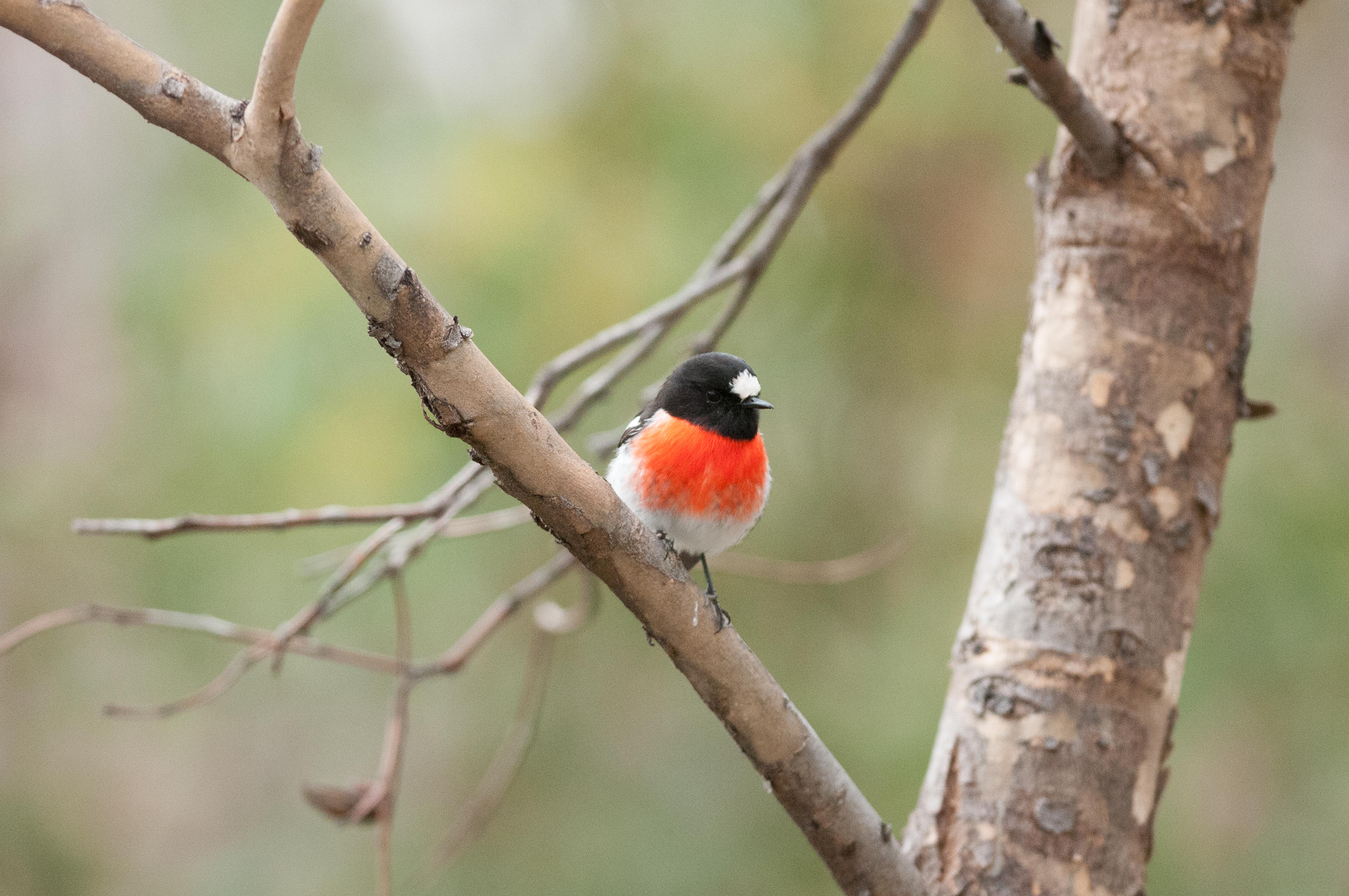
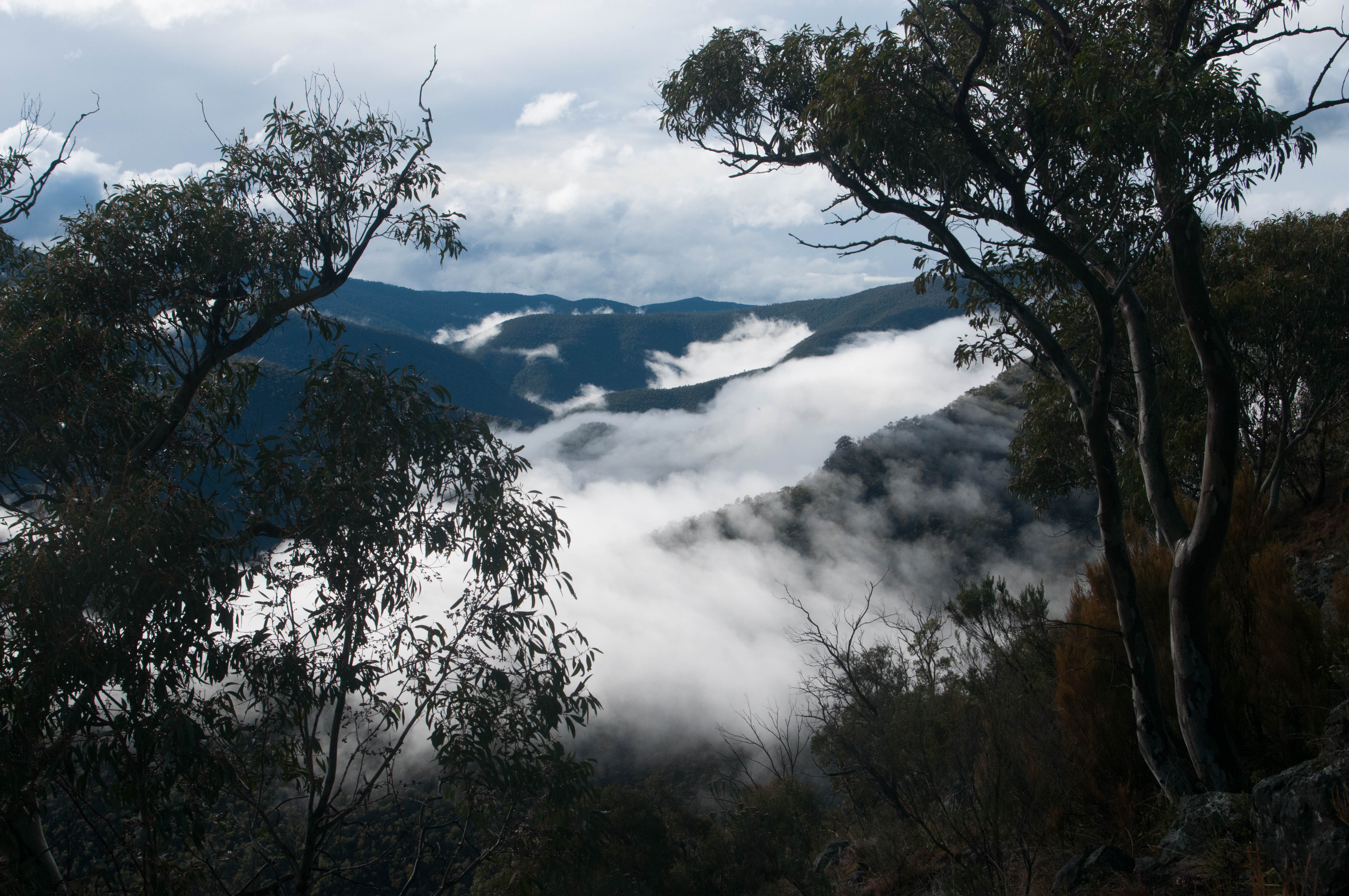
During Margie’s and my recent trip to Hattah Kulkyne National Park we took photos of a number of birds encountered in the Park, and along the way. Photographing birds is very enjoyable and most rewarding. Some birds were quite elusive and were difficult to photograph. Although we could see them at a distance they would not let us get close enough for a reasonable quality image. It does require a fair amount of patience – and luck. We are keen to visit this area again soon on our quest for more photos of these beautiful subjects!
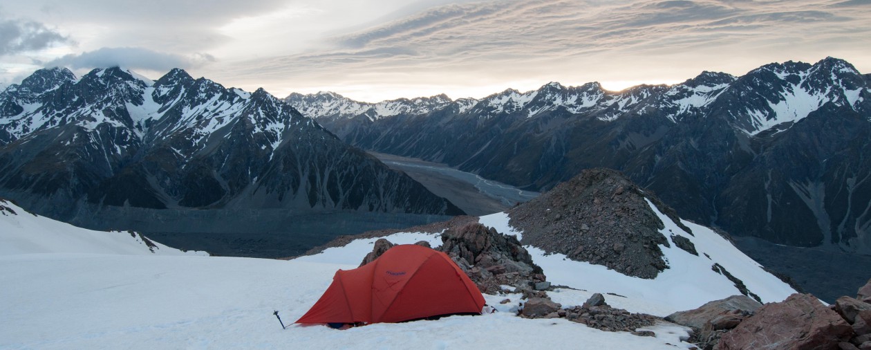
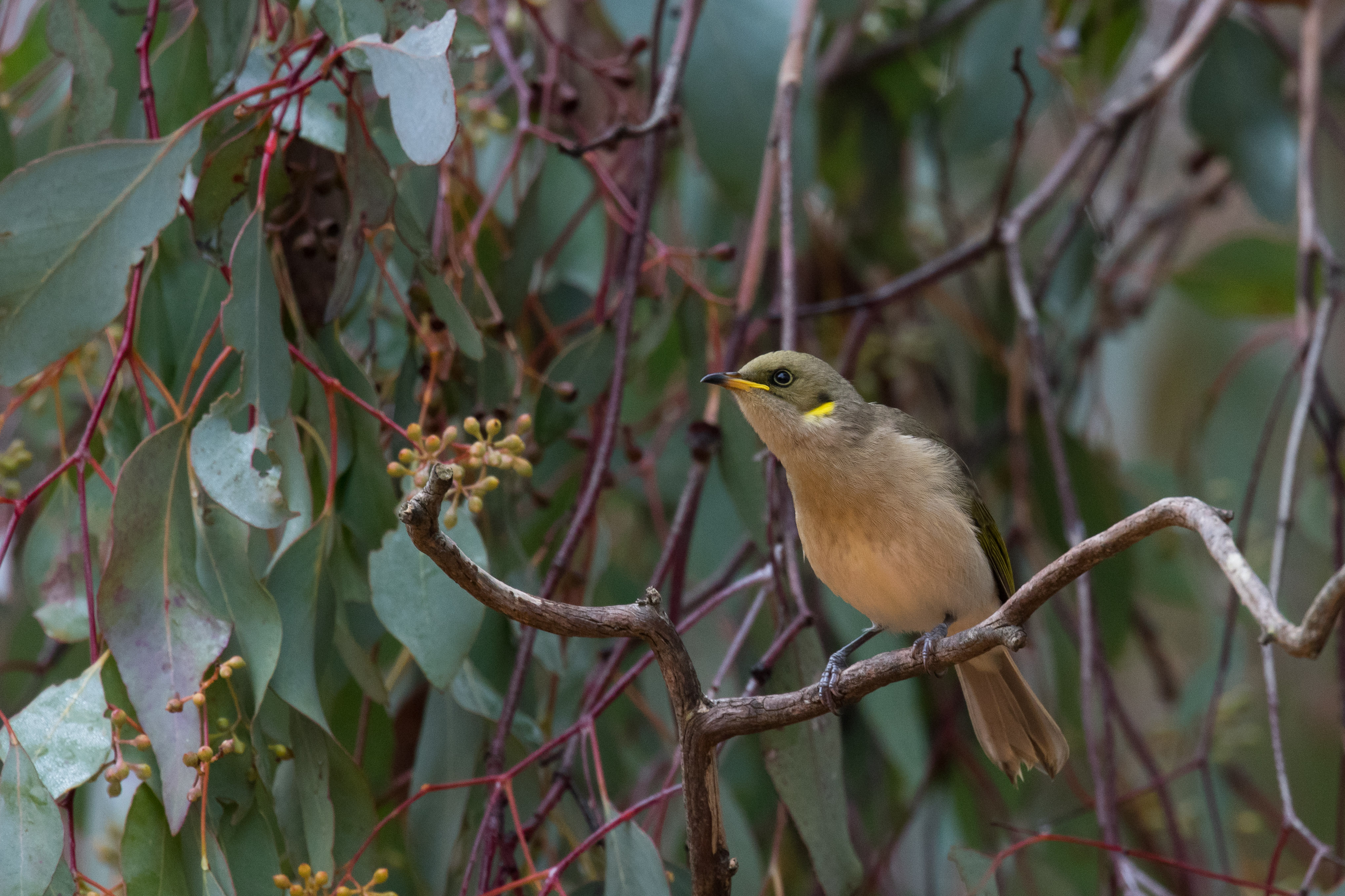
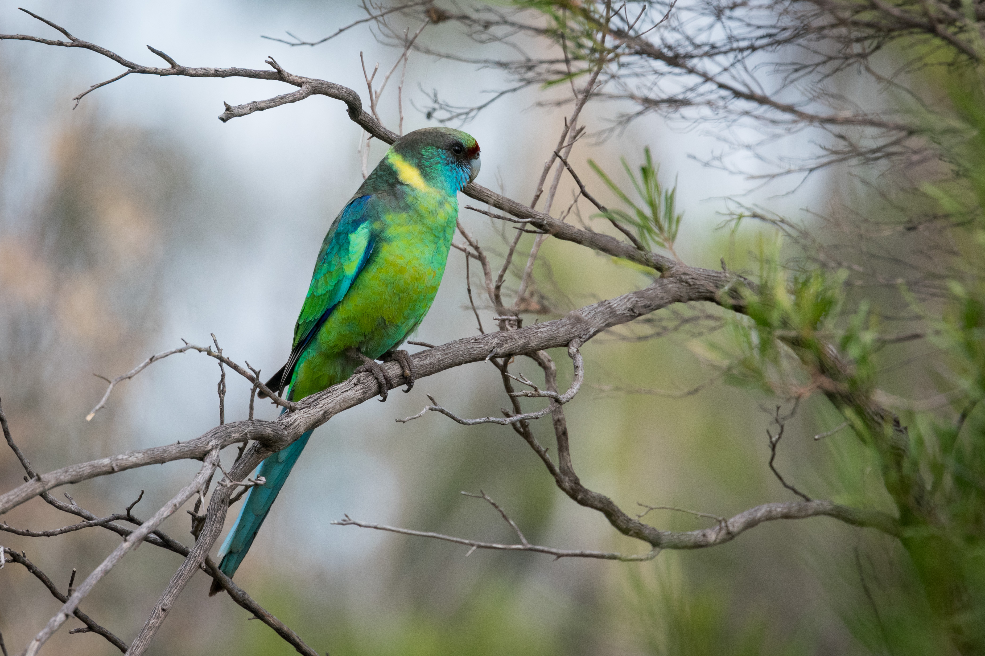
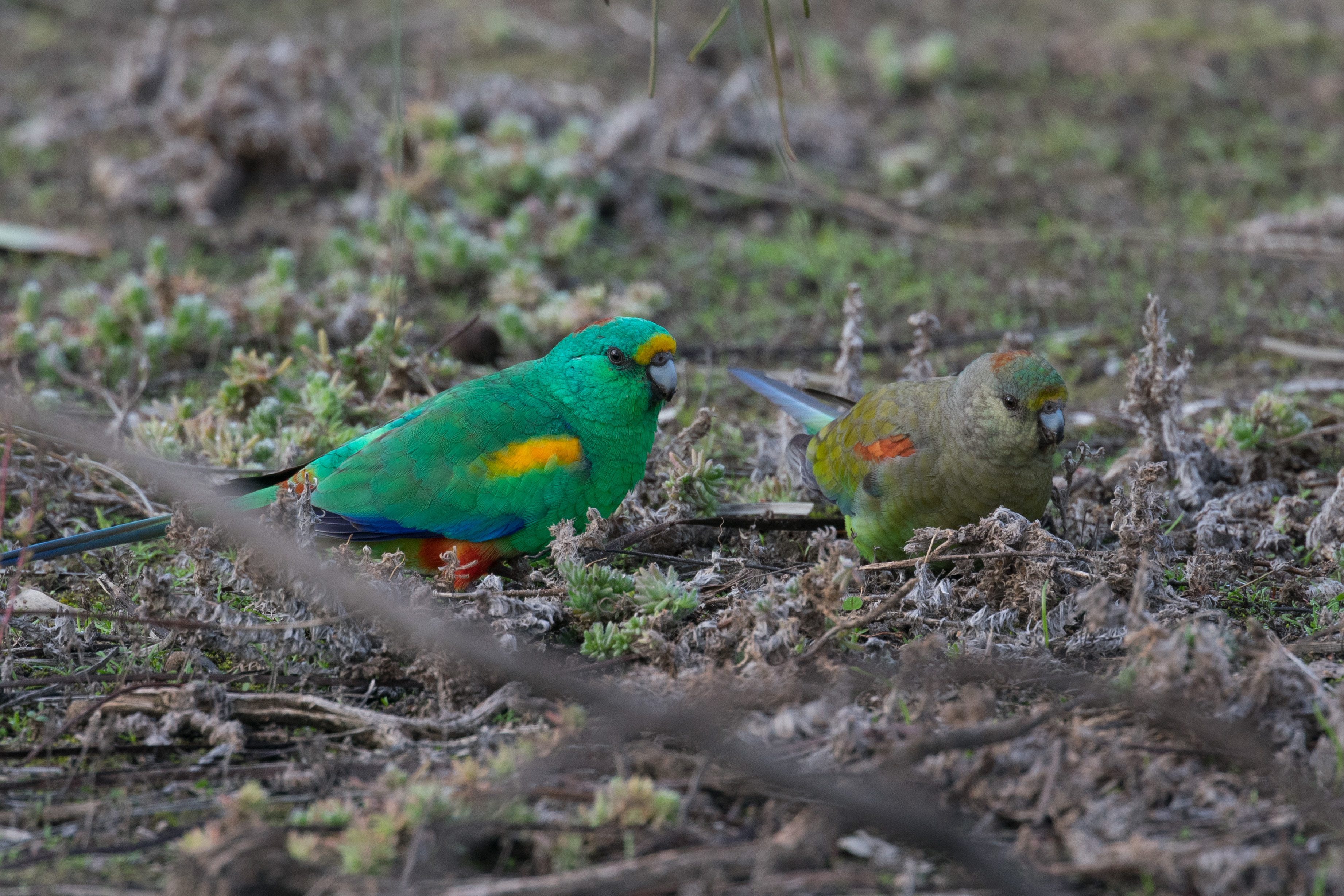
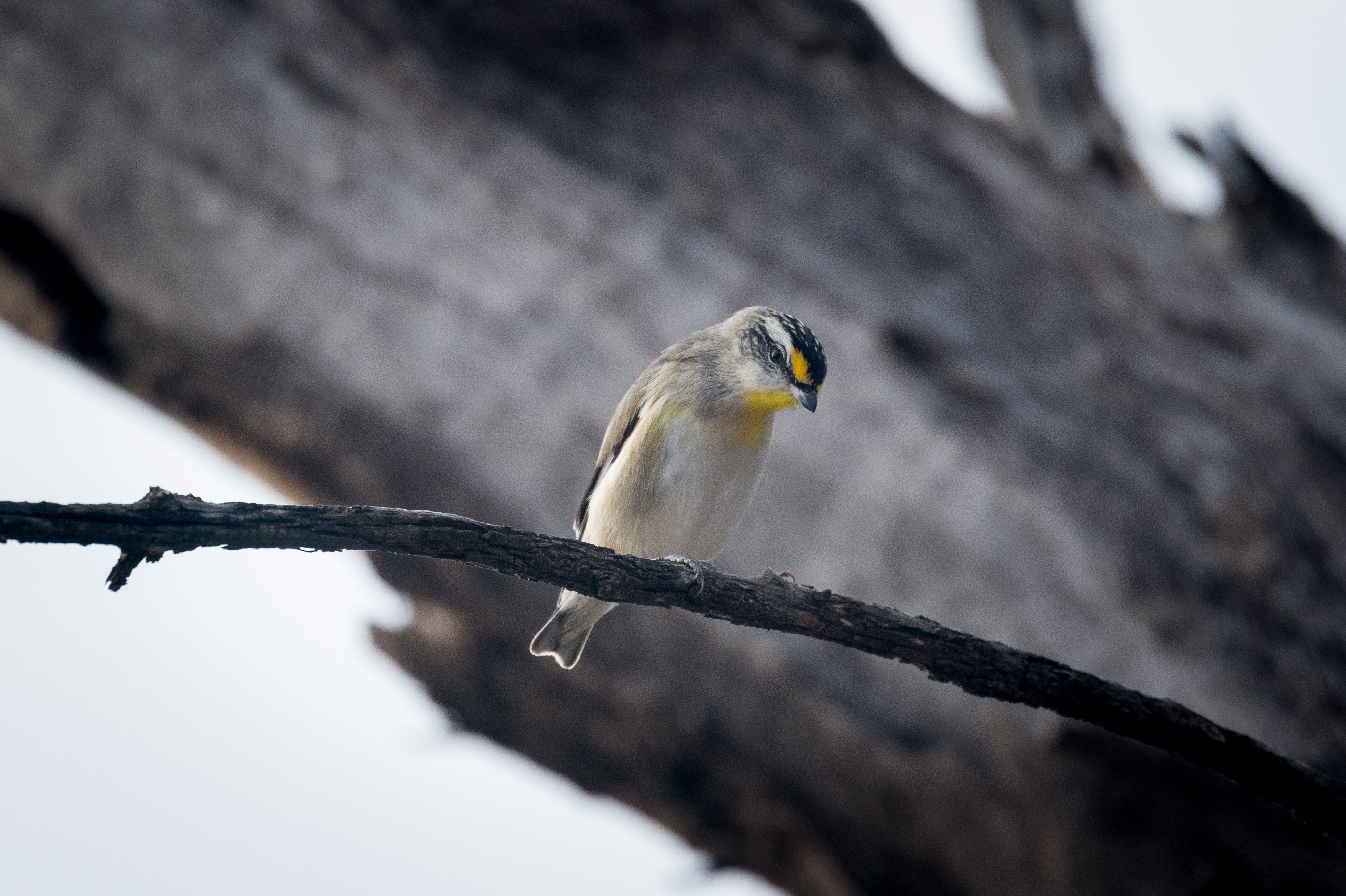
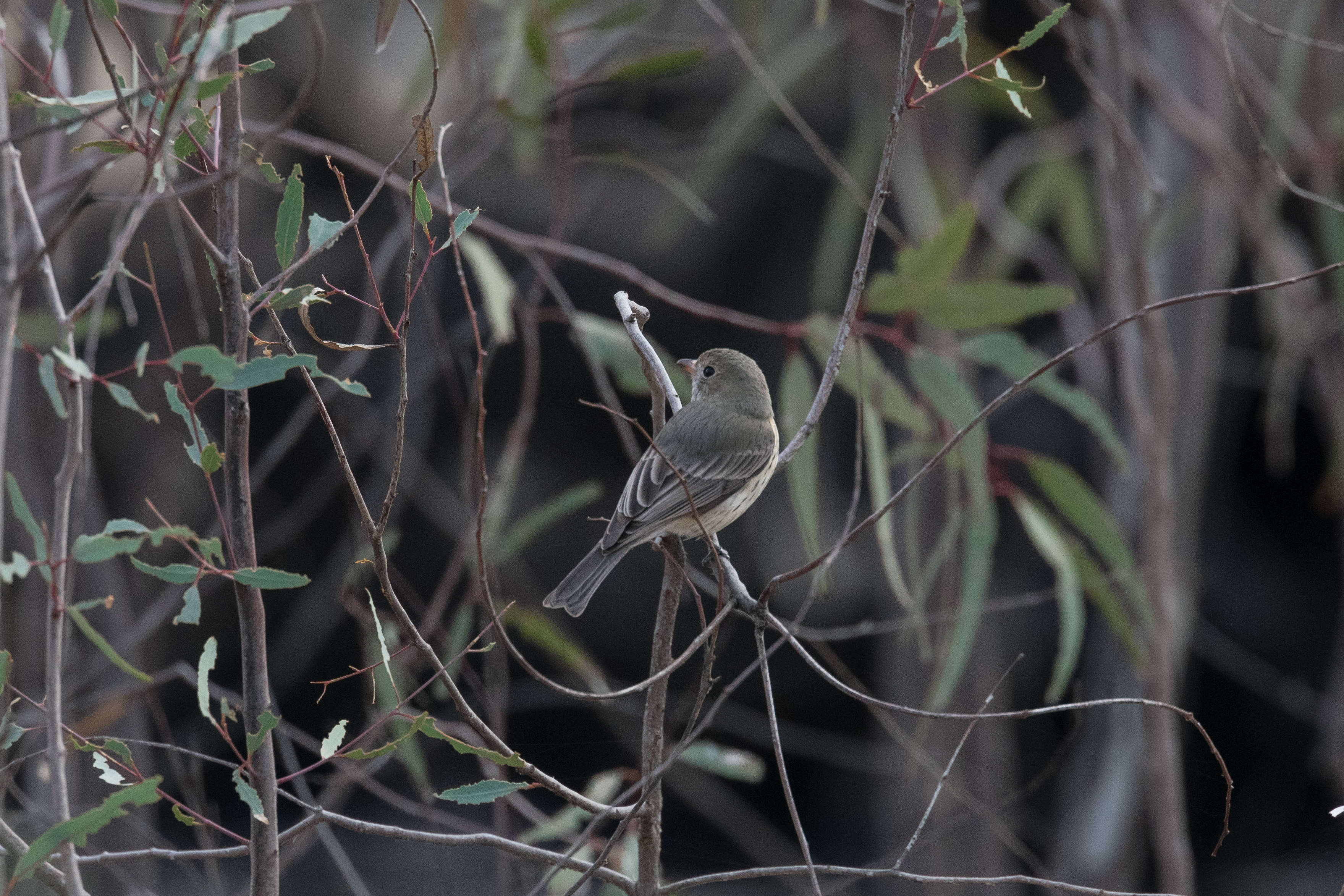
Mallee landscape at Hattah – Kulkyne NP. Taken by Margie. Click to enlarge.Young Yellow-tufted Honeyeater Click to enlarge. 1/320 at f /5.6. 1.4 teleconverter. ISO 800. Cropped. Australian Ringneck Click to enlarge. 1/1000 sec at f /5.6. 1.4 teleconverter. ISO 800. Cropped. Noisy Miner Click to enlarge. 1/320 and 1/800 sec at f /5.6. 1.4 teleconverter. ISO 800. Cropped. Mulga Parrot Click to enlarge. 1/640 sec at f /5.6. 1.4 teleconverter. ISO 800. Cropped.Yellow Thornbill Click to enlarge. 1/800 sec at f /5.6. 1.4 teleconverter. ISO 800. Cropped. Striated Pardalote Click to enlarge. 1/1000 sec at f /5.6. 1.4 teleconverter. ISO 800. Cropped. Jacky Winter Click to enlarge. 1/1000 sec at f /5.6. 1.4 teleconverter. ISO 800. Cropped. Grey Shrike-thrush Click to enlarge. 1/1000 sec at f /5.6. 1.4 teleconverter. ISO 800. Cropped. Australian Ringneck 1/2500 sec at f /6.3. 1.4 teleconverter. ISO 800. Cropped .
The above birds were photographed in the following areas.
Hattah-Kulkyne National Park
We camped at Lake Mournpall. The Hattah lakes system was accessed from near the visitor centre along Mournpall track. Open country, dunes, and lakes fringed with River Red Gums. The following birds were photographed – Australian Ringneck, Mulga Parrot, Striated Pardalote, Grey Shrike-thrush, Yellow Thornbill and Jacky Winter.
Bronzewing Flora and Fauna reserve
Bronzewing has no facilities and only 4WD tracks within the reserve. It is a pristine expanse of mallee woodland well worth spending time in. Unfortunately in early 2014 an extensive naturally occurring bushfire raised large parts of the reserve, which will take many years to recover fully to its former glory, however that recovery is well underway and the dense regrowth is already supporting plenty of birds. (Ref. Birding Victoria, The Mallee, North-West Victoria). Photographed Noisy Miner.
Kara Kara National Park.
This park protects one of the most intact remnants of Victoria’s box-ironbark forests and is important for Swift Parrots and other woodland birds. Photographed Yellow-tufted Honeyeater and White-browed Treecreeper.
Equipment. Camera: Nikon D3400 DX Body. Lens: Nikon AF-S NIKKOR 300mm f/4E PF ED VR Lens. Nikon Teleconverter TC-14E II. Tripod: Gitzo GT5540LS . All images taken using tripod – VR turned off.
18.2km, 980m total ascent (return) – 656m ascent on way in, 324m ascent on return.
This was an opportunity to catch up with our eldest son Jack, aged 26, during his second week of hiking north along the Australian Alps Walking Track (AAWT). Jack had set off from Walhalla in early February with a personal goal to reach Mt Kosciuszko. This would take him a total of 3- 4 weeks, covering a distance of approx. 450 kilometres. It can get lonely on the AAWT after days of not seeing a soul in remote areas, and I knew Jack wouldn’t mind some company for a day. It was also an opportunity for me to explore some parts of Victoria’s most scenic and remote high country
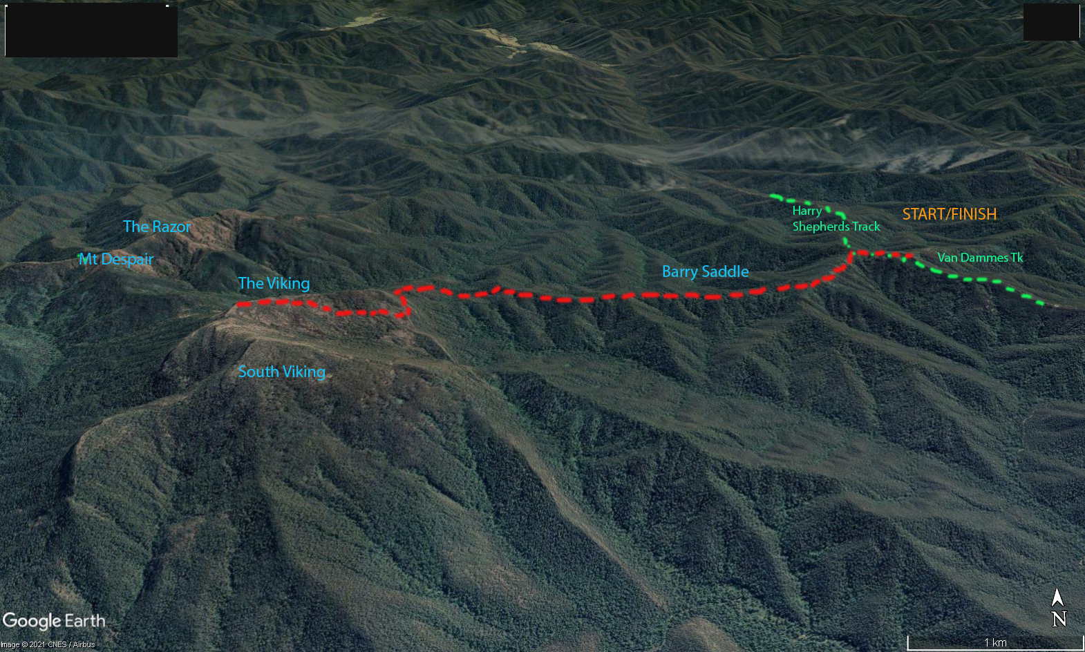
Map showing route to The Viking from Van Dammes Track. Click to enlarge.
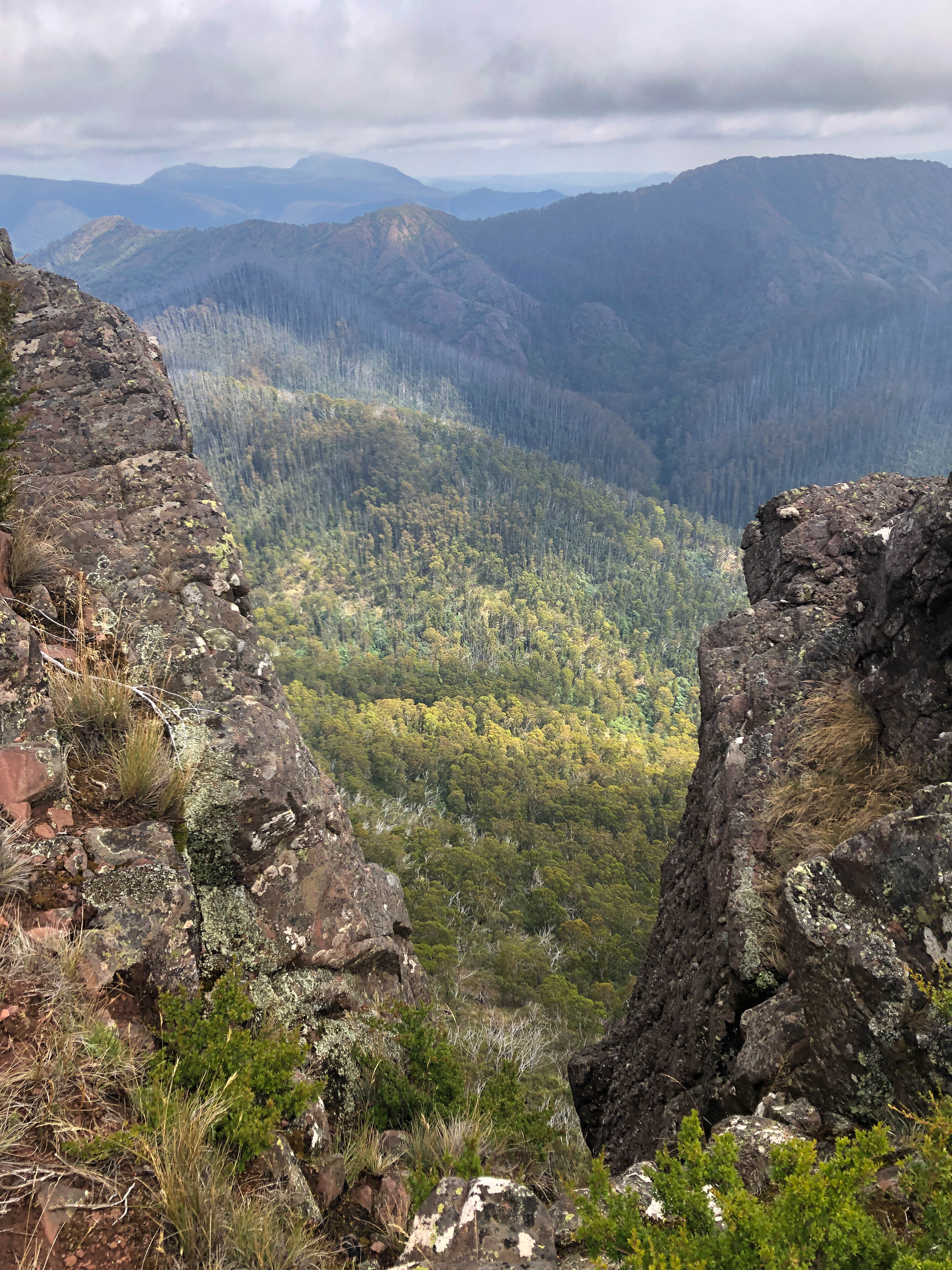
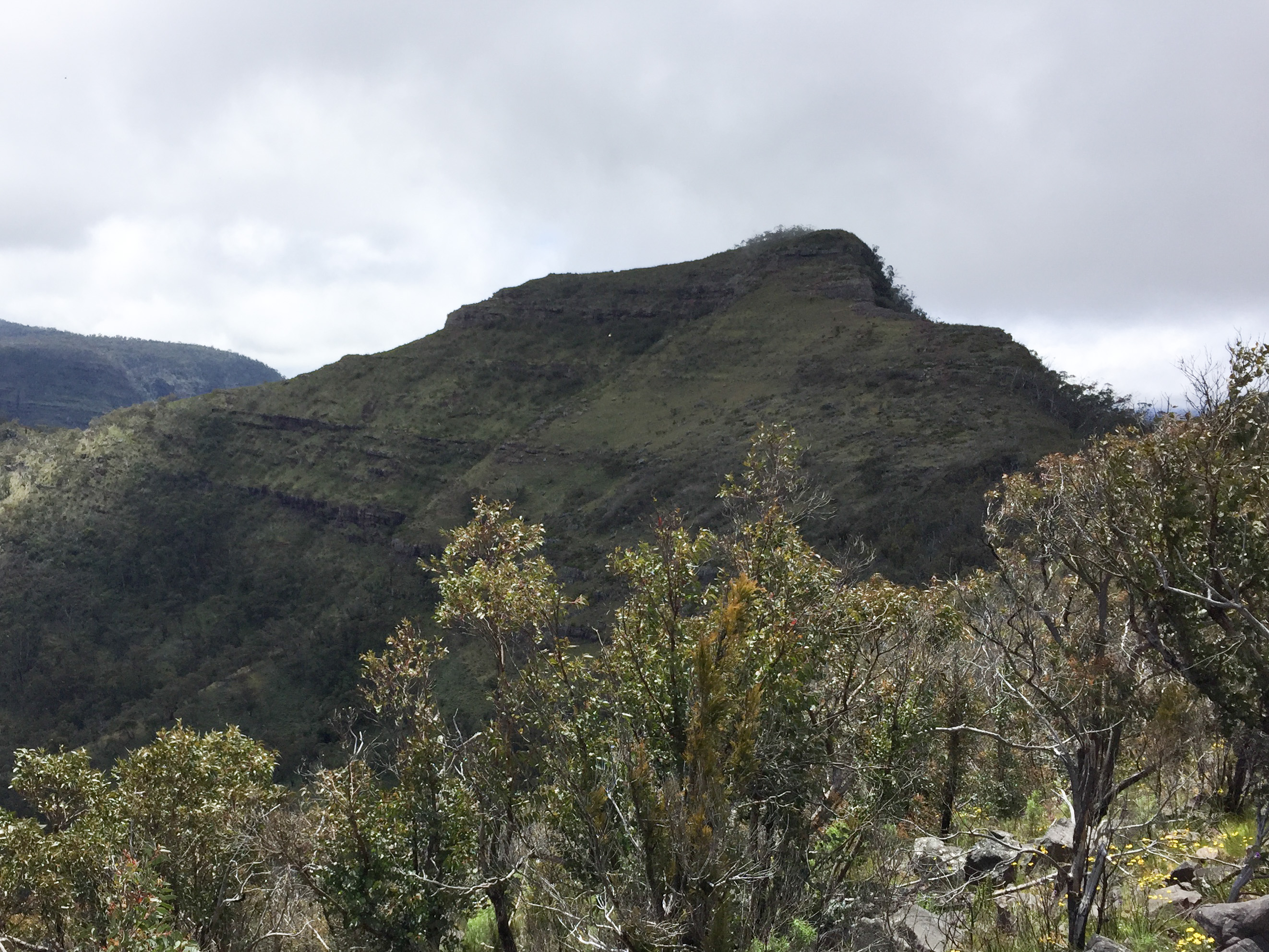
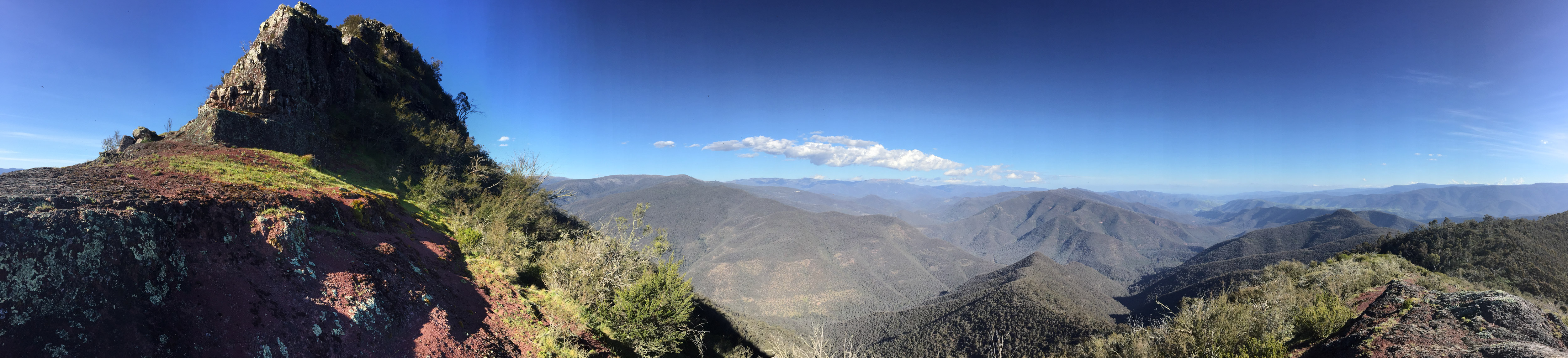
At 7am on that Sunday morning, as Jack was leaving Camp Creek at Mount Speculation, I was leaving Van Dammes Track from the east. We would head towards each other and planned to meet at the top of The Viking around midday. We would be walking in the Razor-Viking Wilderness, part of the Alpine National Park, and without prior local knowledge we could only guess the condition and difficulty of the track. As it turned out the section that I was on had been recently cleared, whereas the section that Jack had to negotiate from Mount Speculation was in much worse condition.
The view towards The Viking from near Barry Saddle. Click to enlarge.
I slept the night before in my swag at the parked car on Harry Shepherds Track junction with Van Dammes Track. It was my intention to walk the nine kilometres to the top of The Viking in about 5 hours. We both had a Garmin InReach Mini for communicating via text message. The February weather was perfect with a nice forecast top temp. of 20 C. As the AAWT guide suggested walkers doing this section camp at Barry Saddle, which was 3.75 km from my car (and about 17km for Jack), I carried my pack as far as Barry Saddle before offloading the tent, sleeping bag and some other items, which I would use, or collect, on my return. Because I was spending a day walking in the Wilderness I carried adequate clothing, water and other gear in event of a weather change or an unforeseen situation. Jack was walking the traditional AAWT direction from south to north.
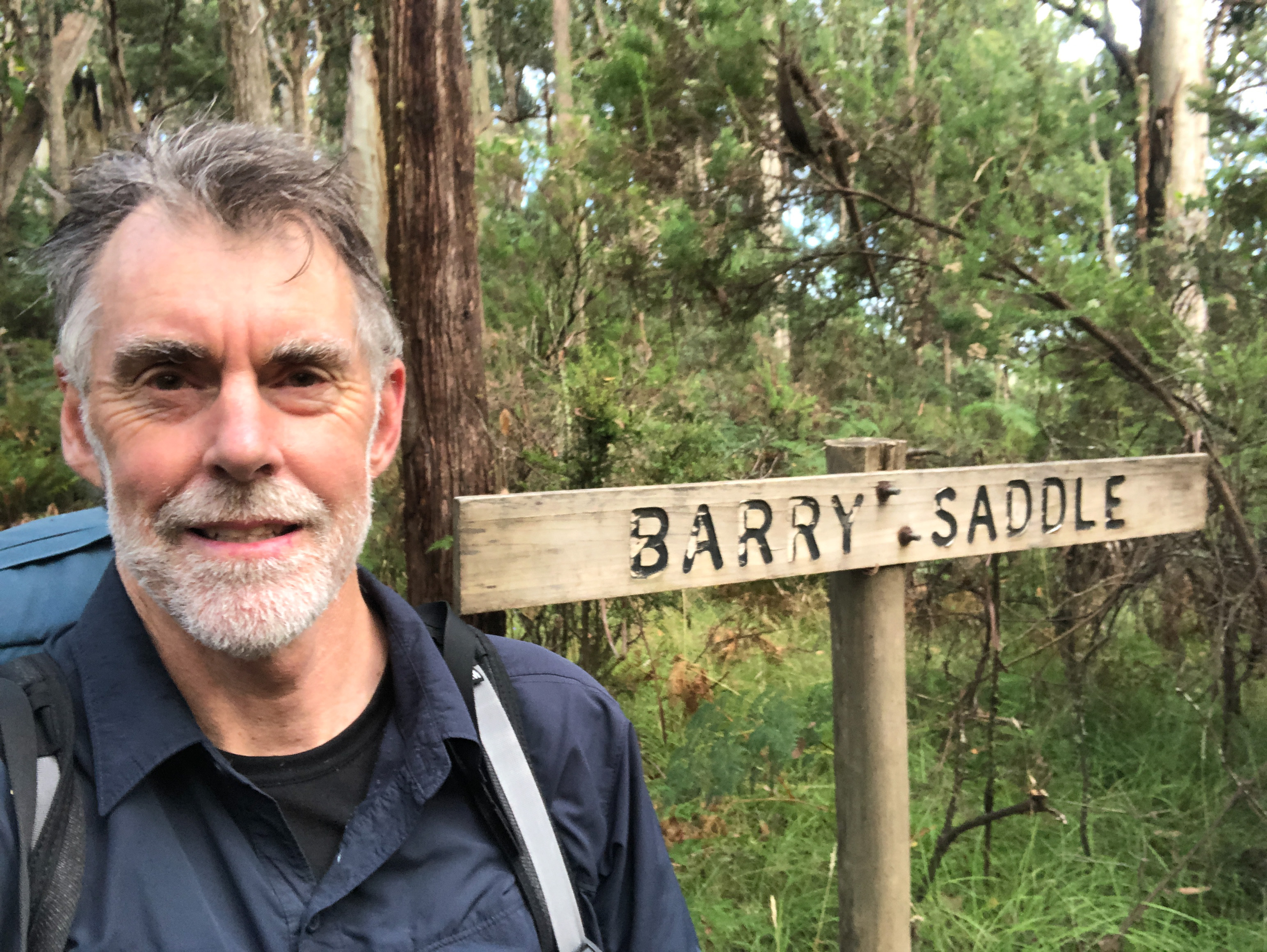
Me at Barry Saddle that morning.
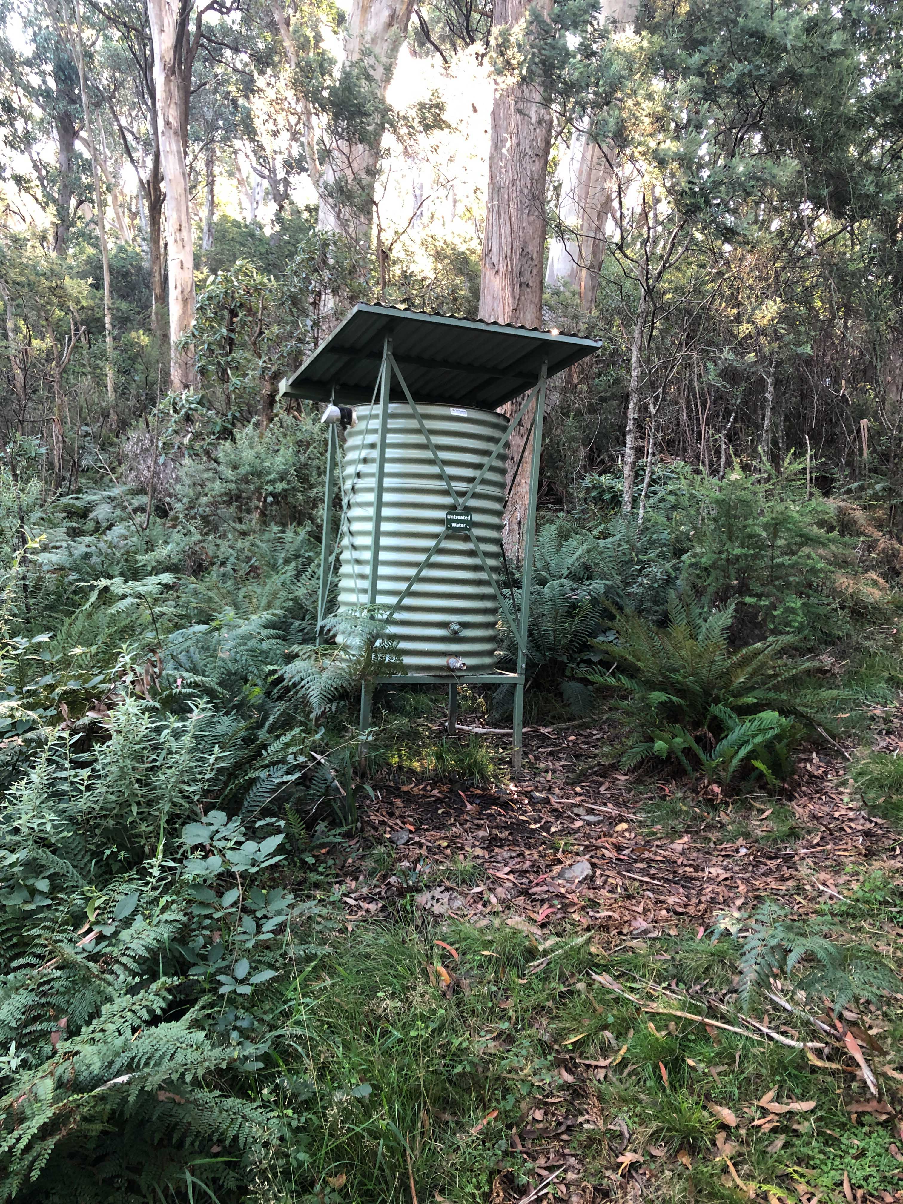
The 3.75 km from Harry Shepherds Track to Barry Saddle was along a nicely maintained and cleared Management Vehicle Track. It was obvious that Parks Victoria staff periodically used this section of track for vehicle access to the camping area. The Barry saddle camping site also had provision of water in the way of a recently constructed roofed rain water tank. This was one of a number of water tanks to provide walkers with drinking water en-route across the dry Barry Mountains.
Without this tank at Barry Saddle hikers would have to carry much more water.
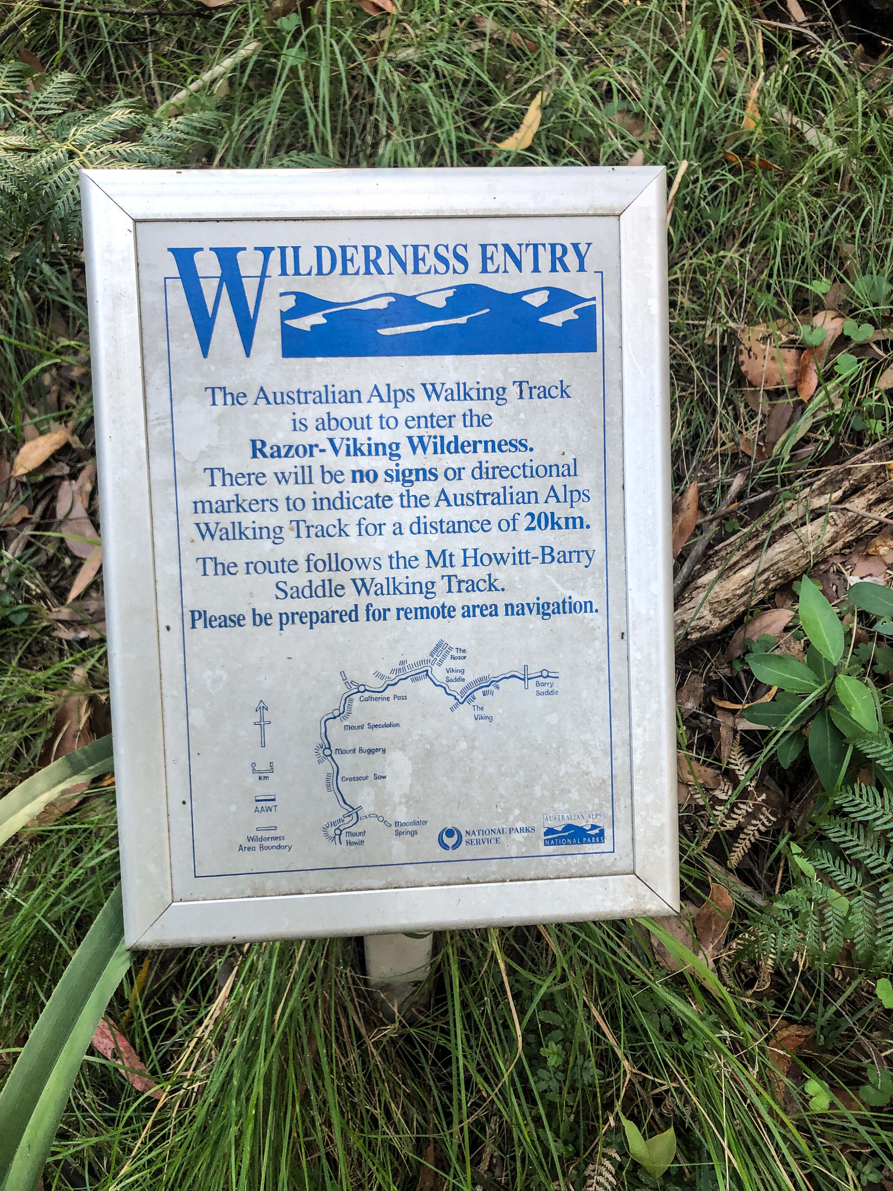
Wilderness awareness sign at Barry Saddle.
I entered my name in the log book and continued walking. For the next three kilometres there were a series of small saddles, similar to the first 3.75 km to Barry saddle.
It appeared that Parks Victoria used a small machine to clear vegetation along this easy gradient section of track as it was nicely cut and cleared to a couple of metres width. The footprint was slightly larger than a normal narrow width track. Any initial unsightly impact of works would have quickly disappeared due to the vigorous regrowth of the vegetation. This mechanical method would have been more cost effective and practical than manual clearing.
About to start the steep uphill climb. Click to enlarge.
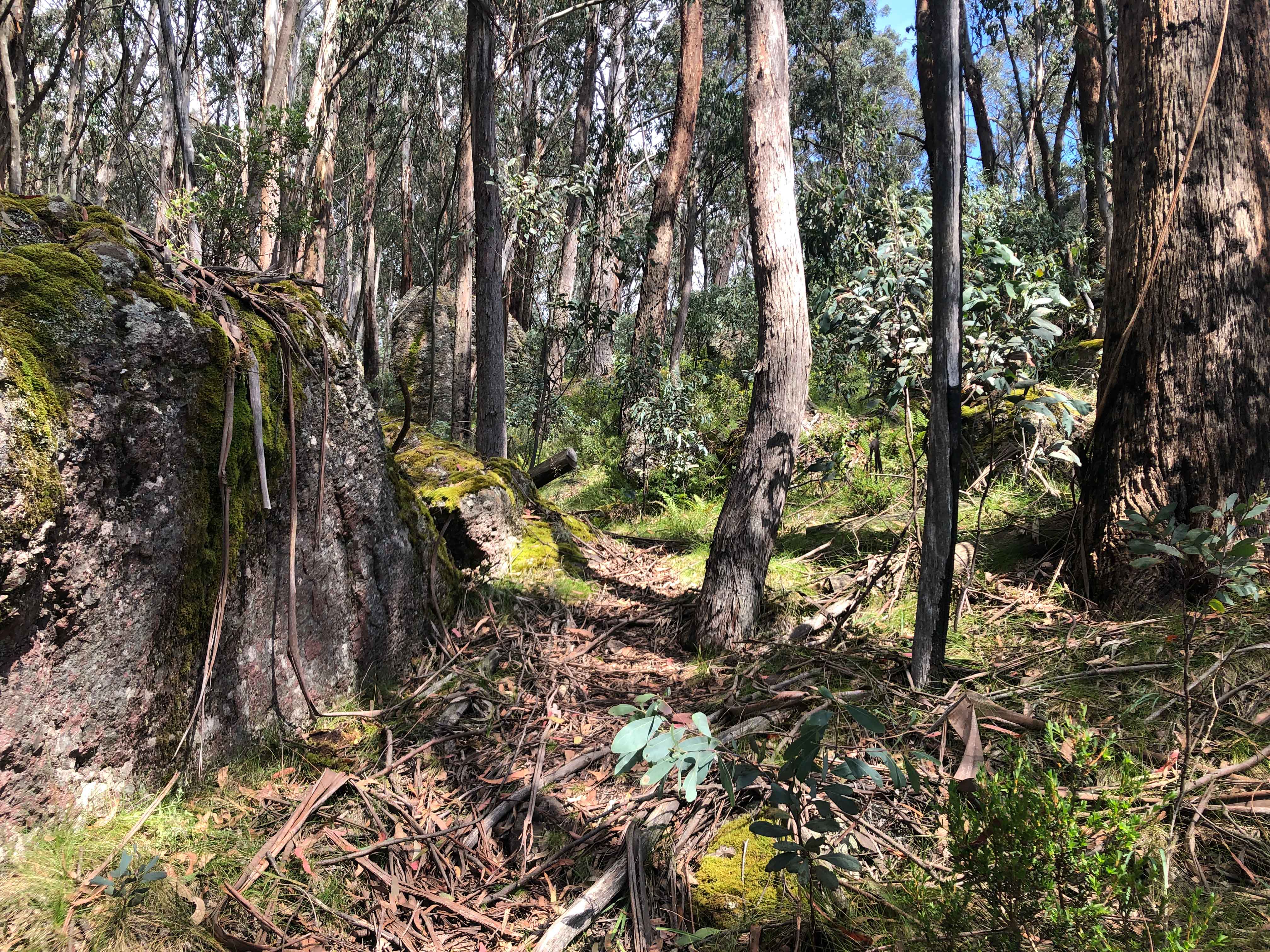
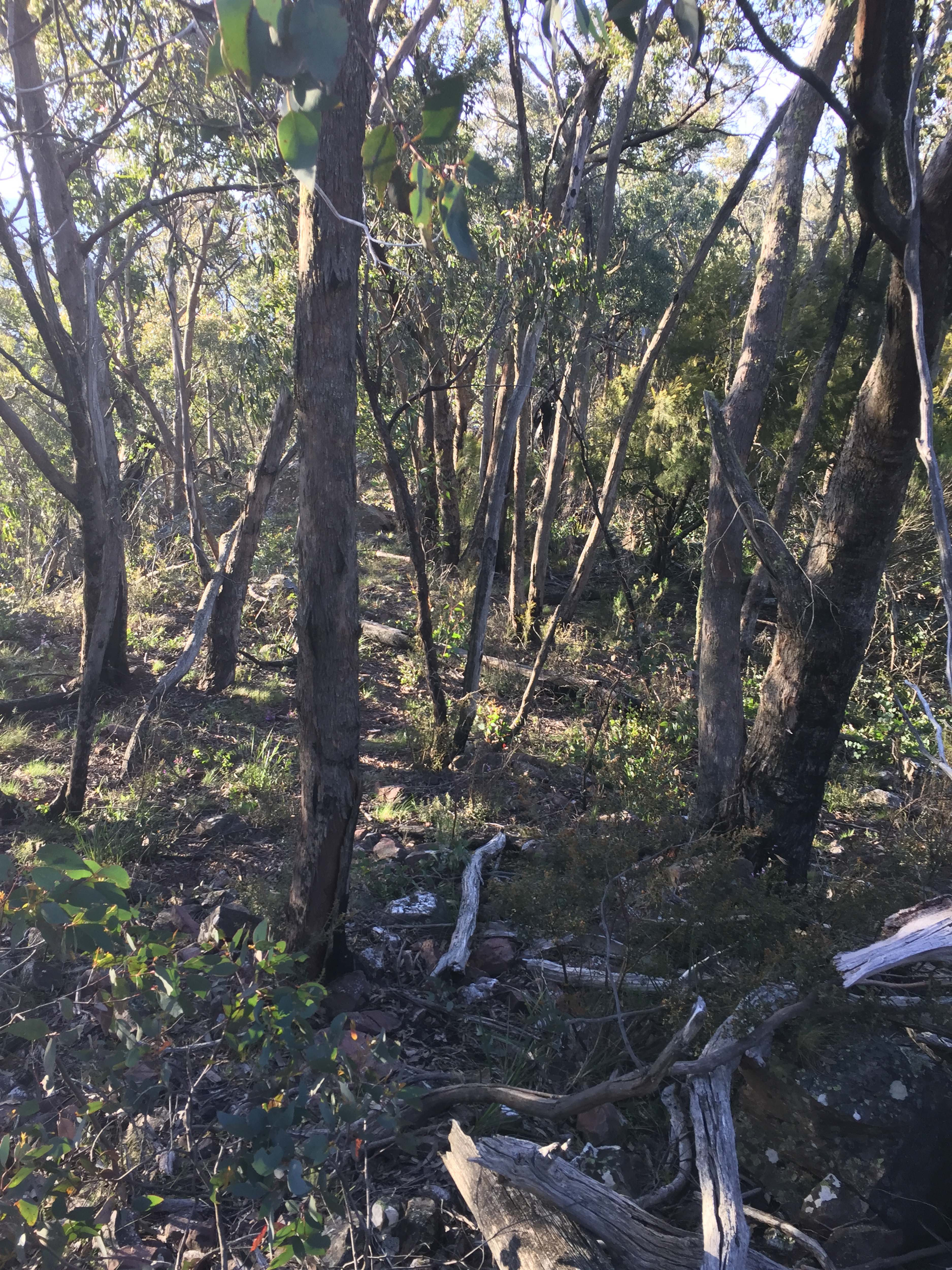
The track narrowed, but fortunately was still quite clear from fallen trees and undergrowth.
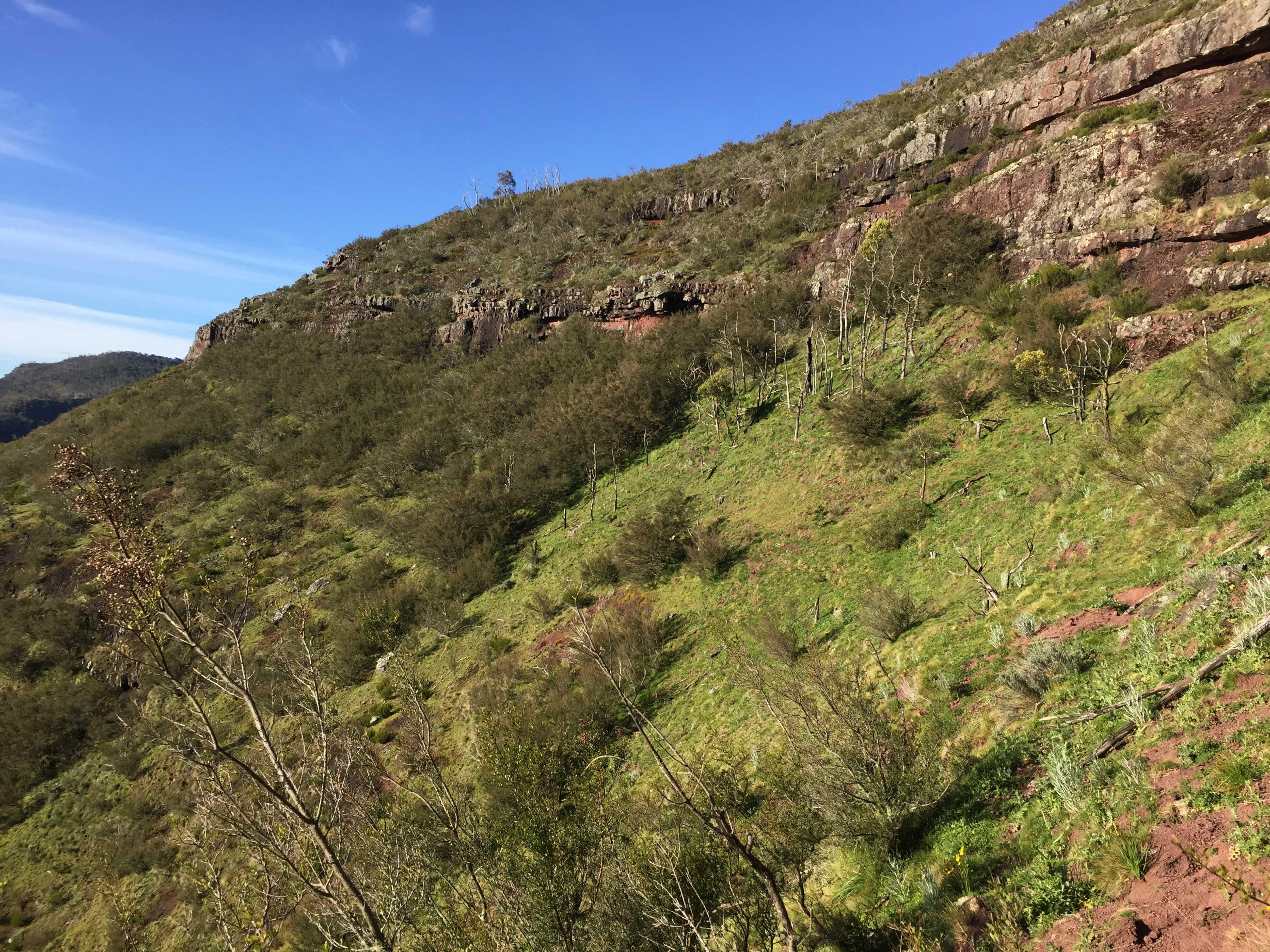
At about the 6km point the track changed from an undulating steady gradient to a steep climb up The Viking. It was quite arduous climbing the 45 degrees slope of The Viking eastern face. The track twisted itself around boulders, rocks and trees on its way to the top. I was soon working up a sweat as I climbed the 500m ascent.
It was however pleasing to see that, consistent with the first bit of this section, all trees and branches had been cleared. My guess is that this would have been carried out by a work crew on foot armed with chainsaw – in the past 12 months. This level of maintenance was completely unexpected after hearing first hand from Jack about the large amount of fallen trees, branches and undergrowth on other sections of the AAWT track, in particular with the section between Mount Speculation and The Viking.
Leveling out towards the top. Click to enlarge.
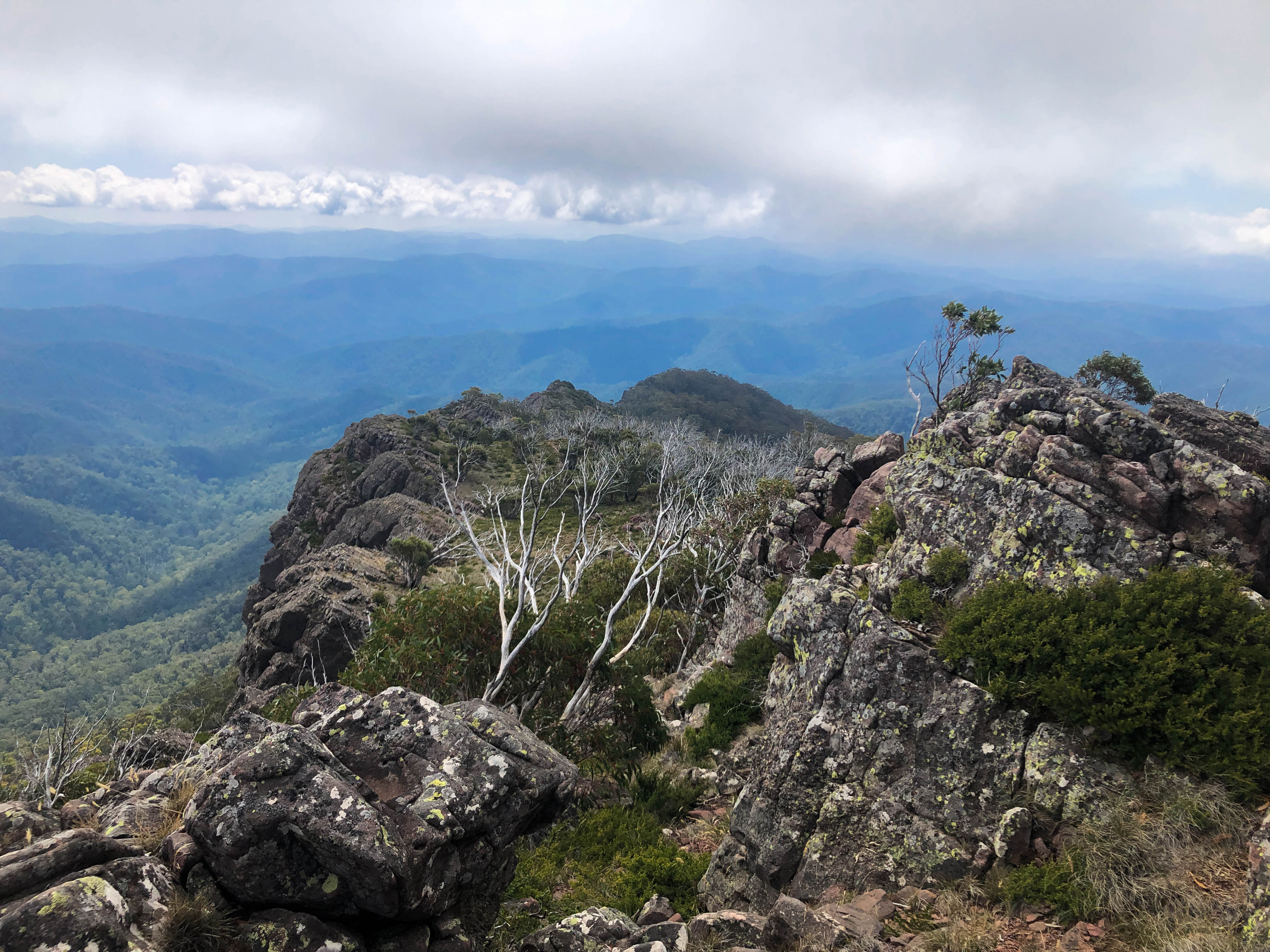
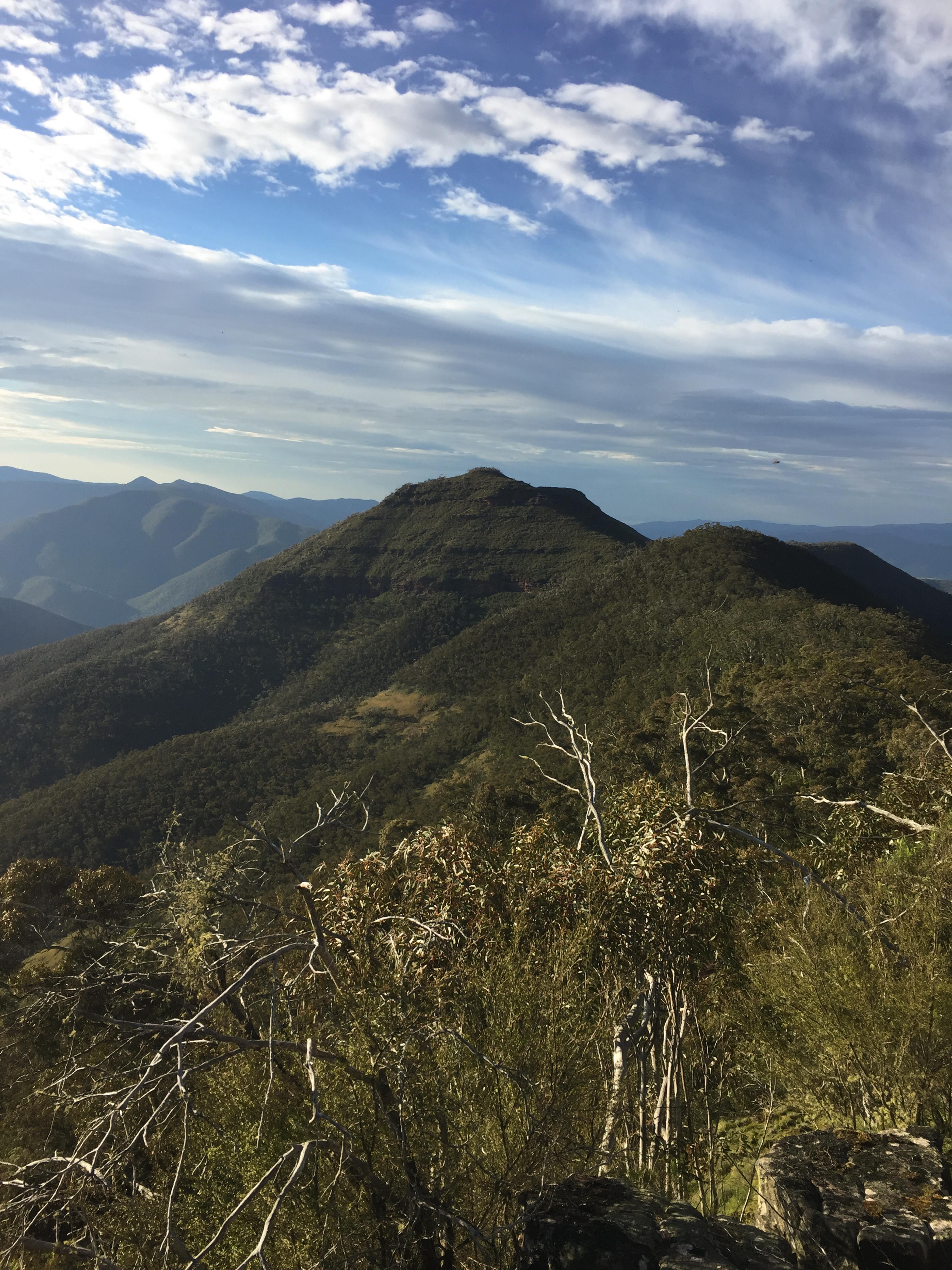
After walking for five hours, which included a few stops for cooling down, I was at the top of the Viking (1508m), taking in the commanding views of the Crosscut Saw and Mt Speculation to the west, and Barry Mountains to the east. There was mobile phone reception so I was able to read Jack’s track log on Garmin MapShare after sending a message using inReach letting him know where I was. Jack arrived at 1.45pm. Although covering a similar distance to me, he was confronted with numerous tree trunks and branches.
There were a few short sections where the track was overgrown. Alpine Oxylobium, a native species around a metre in height is common at the higher altitudes, which characteristically spreads across any track forcing oneself to have to push through its dense foliage.
Just before the top of The Viking. Click to enlarge.
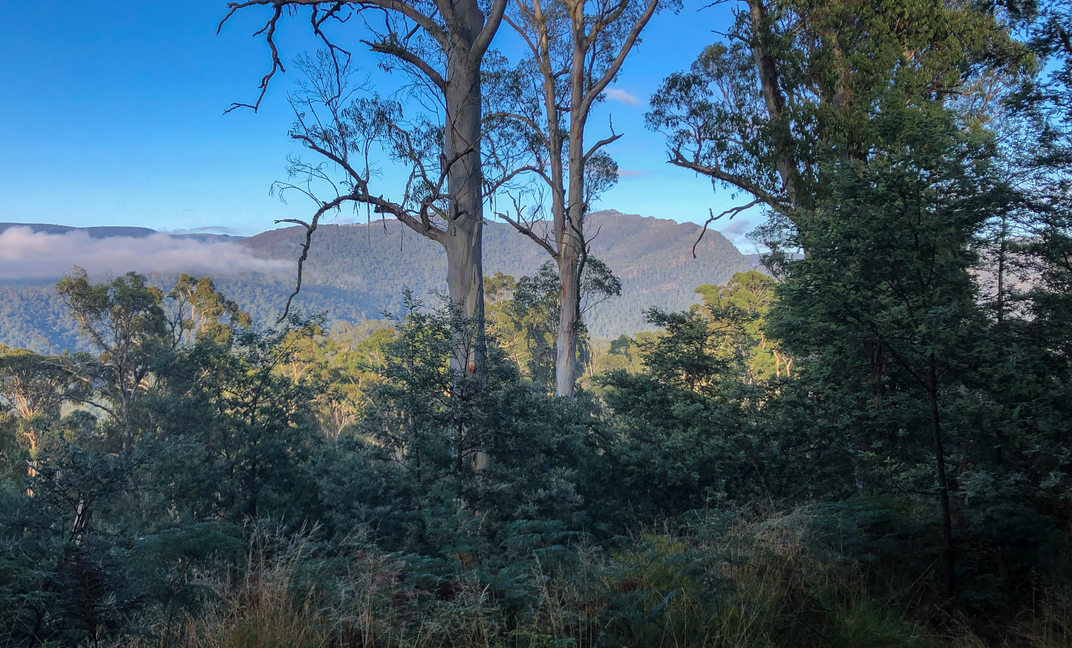
Looking west through a window in the escarpment towards Mt Despair and The Razor. Click to enlarge.
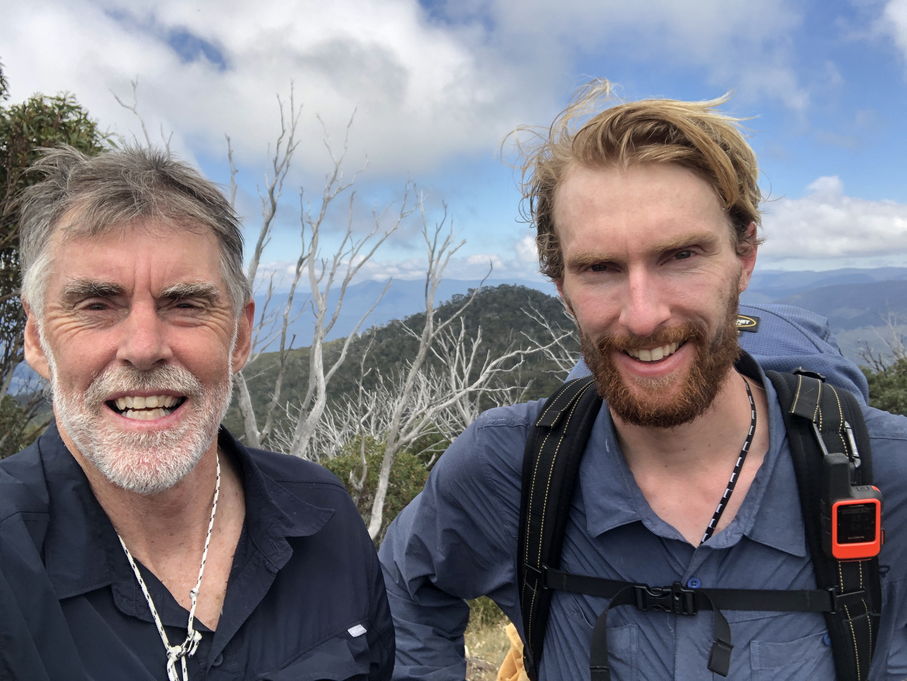
Jack at our meeting point.
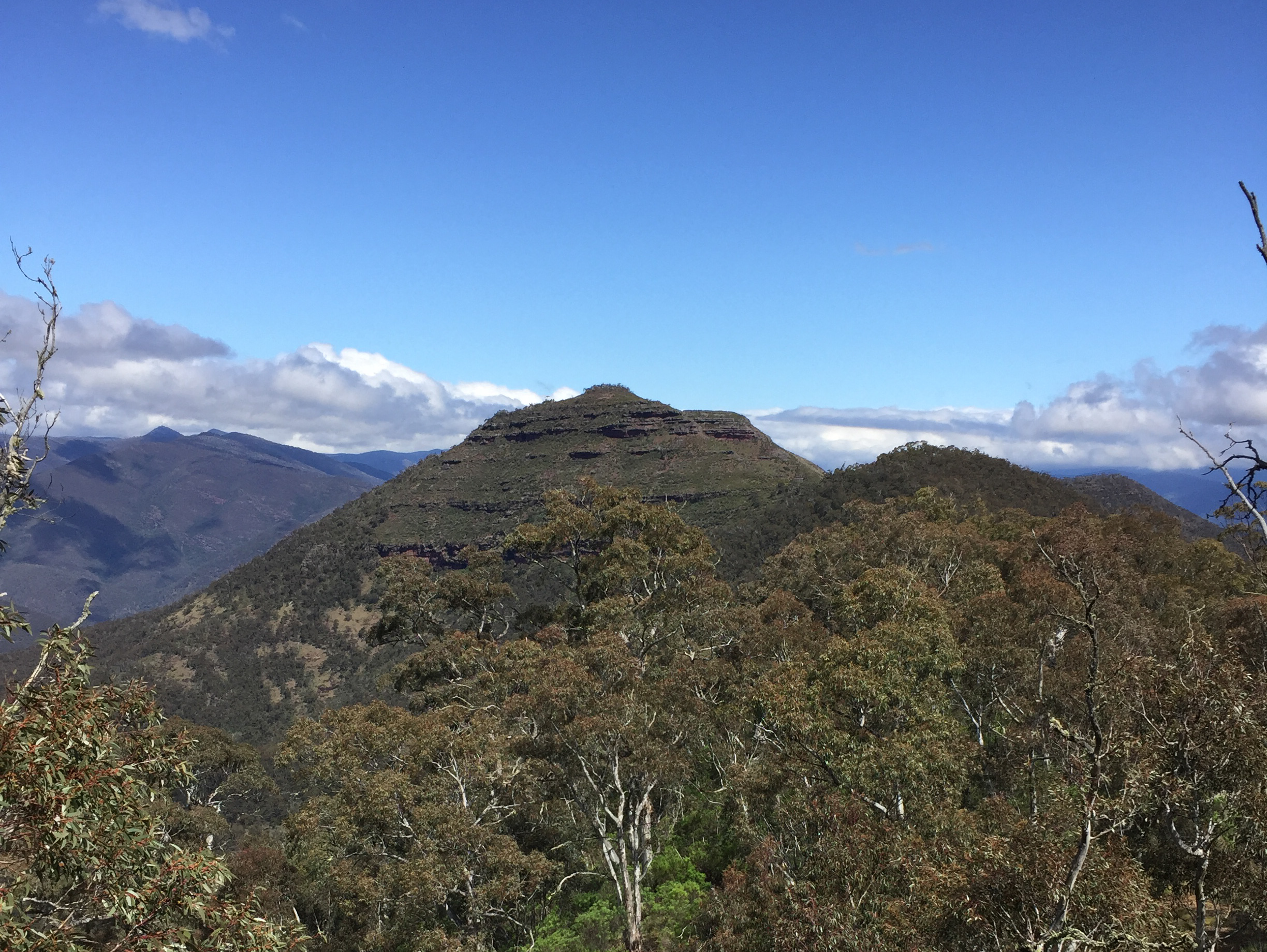
View from the top of The Viking, looking north. Click to enlarge.
At the top.
We brewed a cuppa, had some lunch and then proceeded back the way I had come. After stopping at Barry Saddle to replenish our water bottles and collect my tent and other gear we walked the remaining 3.5 kilometres to my car, arriving just after 7pm. We camped the night. Jack continued on his walk to Kosciuszko the next morning.
Dropping off The Viking with a view east towards Barry Saddle. Click to enlarge.
Can’t complain about the inspiring view, or the nice weather.
The standard of the AAWT varies a lot. It must depend on land manager resourcing priorities, and amount of focus by park staff, and also the amount (or lack of) use. It was very fortunate for me to walk a section of the AAWT that had been given exceptional attention! How lucky was I. In some state forest areas to the south, trying to follow the AAWT is apparently more like bush orienteering than hiking.
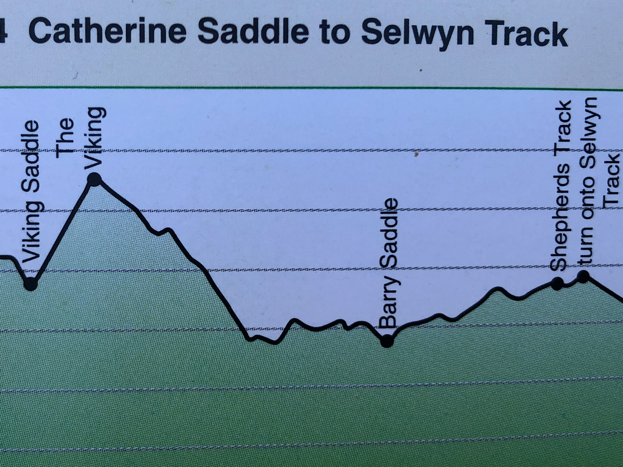
This chart shows the change in elevation – each horizontal line is 200m in elevation.
This walk has spurned me on to do the multi day Viking Circuit. Unlike most that do it in three days I think I’d break it up into four days. Walking from Camp Creek to the Wonnangatta River is a long day. There is a flat spot for camping near the top of The Viking, about 100m on the track towards Barry Saddle which will break up the second day. The only drawback is that water is particularly scarce around the Viking, and a portion of the Viking Circuit is on unmarked tracks.
As I am writing this Jack is nearly at Mt Kosciuszko. He is looking forward to stopping and having a much deserved rest. Jack’s feet are sore with the odd blister, and other parts are hurting, but I would say that he’s now fitter than ever before. It will take many weeks of home cooking to replace the lost kilo’s. This has been a massive undertaking for Jack, with weeks of planning and organising. Part of his preparation was to deliver food drops in advance at predetermined locations, as there are virtually no opportunities, apart from Mount Hotham, to re-supply along the way. A fantastic achievement and amazing effort by Jack.
Rabbit Island is about two kilometres off the east coast of Wilsons Prom National Park. In March 2019 a group of us spent a weekend of adventure at this idyllic part of the coast. This is a short (4 min) video of our trip. At https://youtu.be/ACYIQ7SOGig
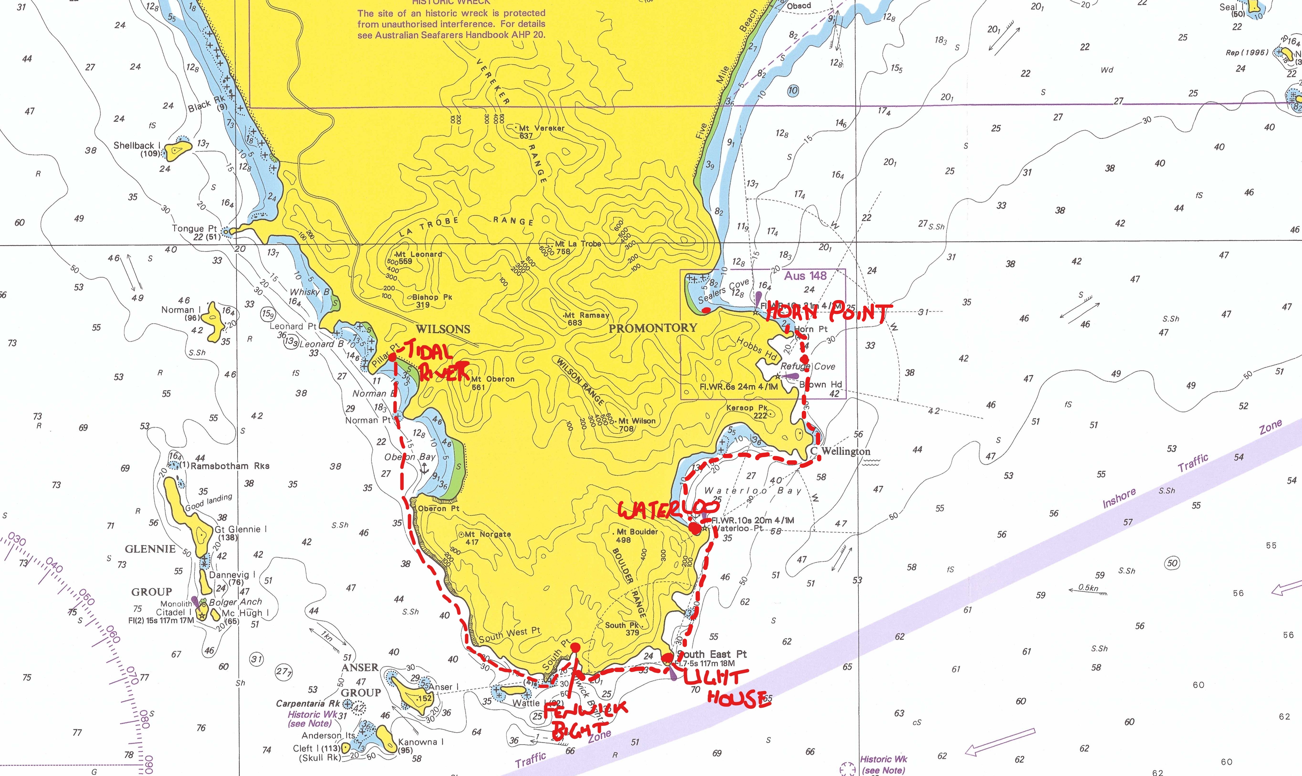
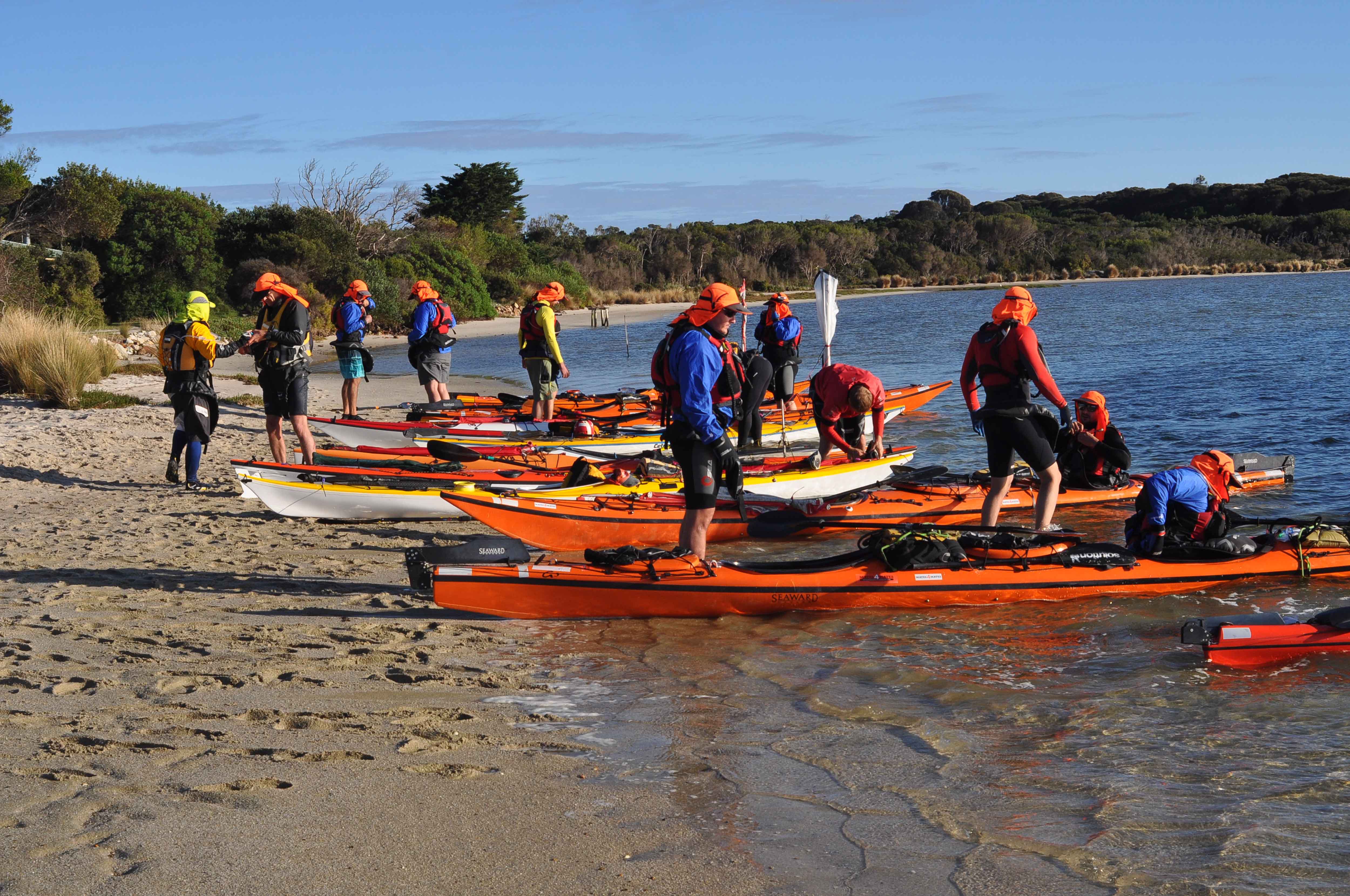
Day 1: Setting off from Tidal River. Derek, me Peter and Steve (L to R).
During the Labour Day long weekend in March 2018 four of us paddled (and sailed) our sea kayaks around the southern tip of Wilsons Prom National Park, from Tidal River to Port Welshpool – a total distance of 90 kilometres over 3 days.
Shortly after this trip I posted a video on Youtube (see address at bottom) and never got around to doing a blog until now. I thought it would be of value to further cover the adventurous aspect of this trip.
The Prom has a wonderful coastline with so much to offer. Paddling a kayak keeps you close to nature and the elements, and makes for a great adventure but can also be risky as I was to find out on this particular trip as I capsized with the sail up, out from the coast with a strong offshore wind.
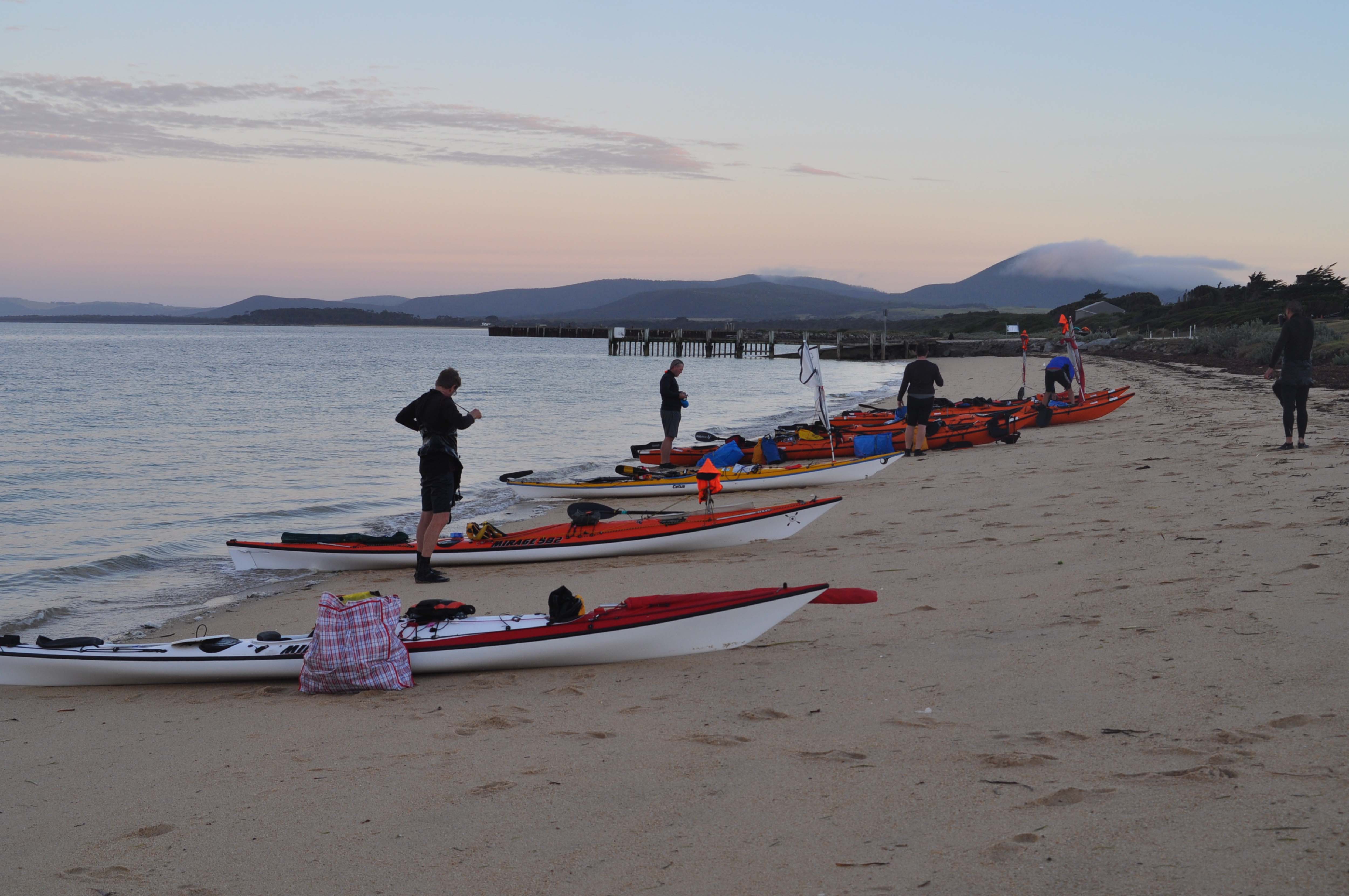
Day 1: Lunch stop at Fenwick Bight – between Tidal River and Lighthouse.Night 1: Waterloo BayMap showing route paddled from Tidal River to Horn Point. Night 1 at Waterloo. Night 2 at Horn Point. Day three Port Welshpool.
DAY TWO
On day 2 (Sunday) of our 3 day kayaking trip, we were planning to paddle from Waterloo Bay to Refuge Cove. The forecast was for 15 knots from the West so we weren’t too worried about the conditions. We were on the protected side of the Promontory. As we rounded Cape Wellington we pulled into a small sandy beach below Kersops Peak. After a brief stop we then set off for Refuge Cove – or so we thought!
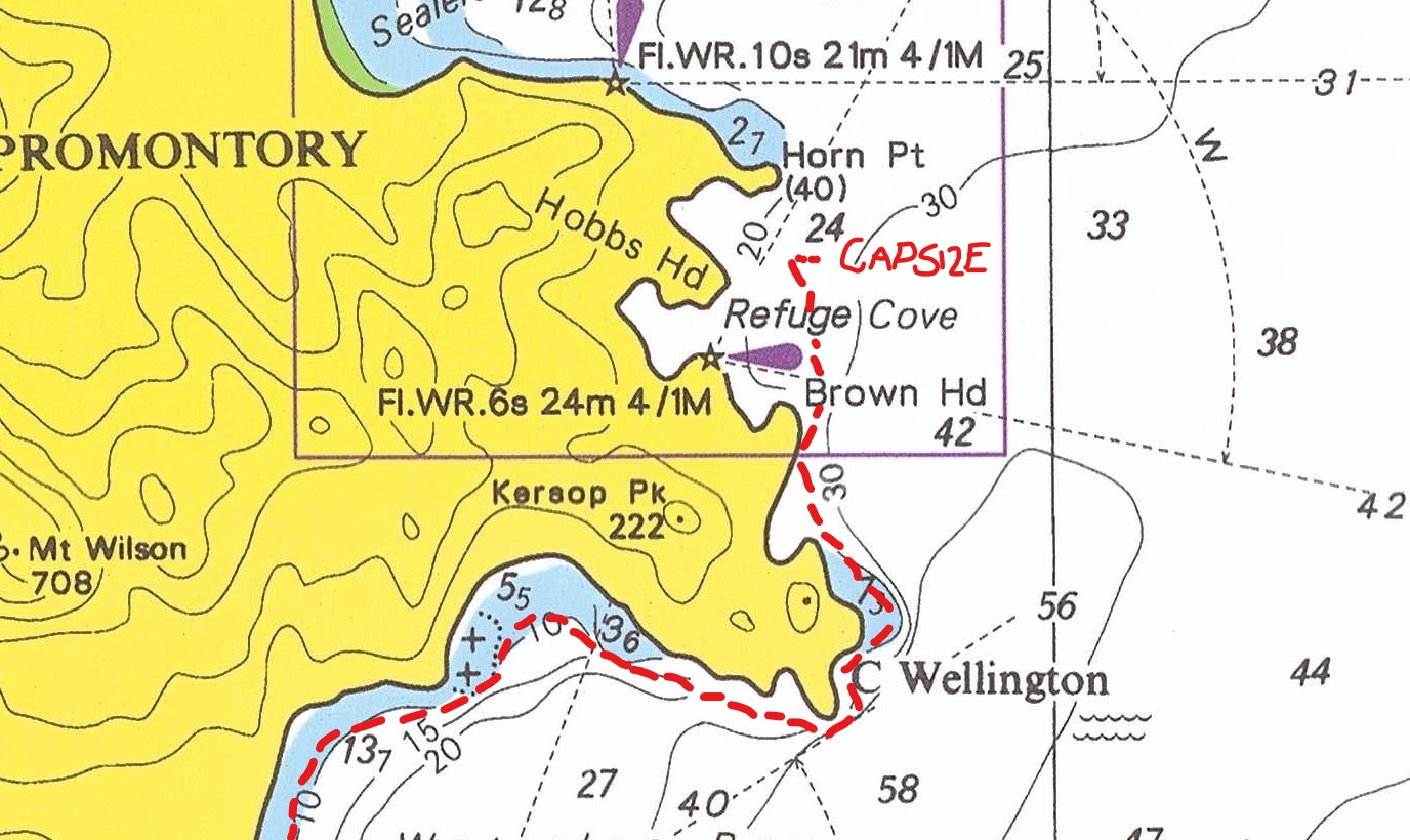
Peter was navigating, and up until this point had done an excellent job, so Steve, Derek and me didn’t personally pay much attention to the landmarks nor refer to our maps or GPS. Unfortunately Peter somehow missed Brown Head, which is when we should have hugged the coast into Refuge Cove. Instead we continued on across Refuge Cove towards Horn Point. The distance between Brown Head and Horn Point is 1.75 km. It was halfway across the Cove when I got into trouble.
Map showing location of capsize at Refuge Cove – south east Prom.
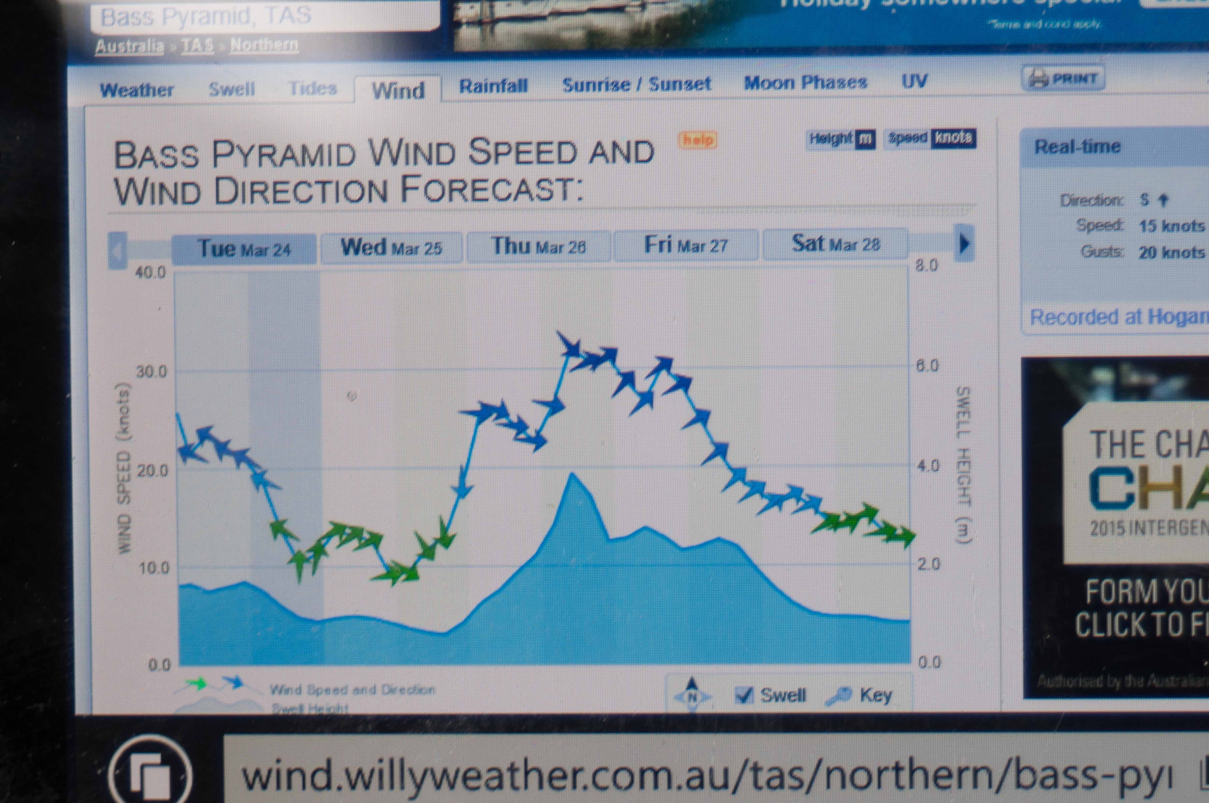
Willy Weather chart for Sunday 11 March 2018. Note that Wind Real-Time after midday was over 30 knots – well above forecast!
At the time there was a strong off shore wind which was trying to blow us out to sea. I was a short distance behind Steve, Peter and Derek on the lee quarter and was attempting to get back close to them. My sail was fully up-hauled but I was struggling to make any progress in closing the gap to the others. I was contemplating dropping my sail and paddling upwind when without warning a strong gust tipped me over. I had to wet exit because the sail was up, which makes it very difficult to perform a roll. Upside down I pulled my spray skirt tab and was out of my boat. By the time I packed my sail up, which took a few minutes, I noticed that Steve and the others were still heading off in the distance unaware of me out of my boat. The time was approx. 11:15 am.
I immediately tried a re-enter and roll but was unsuccessful. The seas were getting choppy and I was drifting away from the coast. Getting back into your boat is not easy in these conditions. With a re-enter and roll it takes at least 15 seconds to place your feet in the cockpit whilst upside down (underwater) and set the paddle up for a hip flick and roll back upright. My first attempt failed partly due to my water container coming loose in the cockpit and restricting placement of my legs. Holding your breath for a second attempt is a real challenge. The next alternative action for emergency self- rescue is to use a paddle float. Mine was stored away in my day hatch, not ideal but still accessible. Before I went for my paddle float I had another look around and to my surprise noticed a large boat in the distance. It was approaching my direction so I waited.
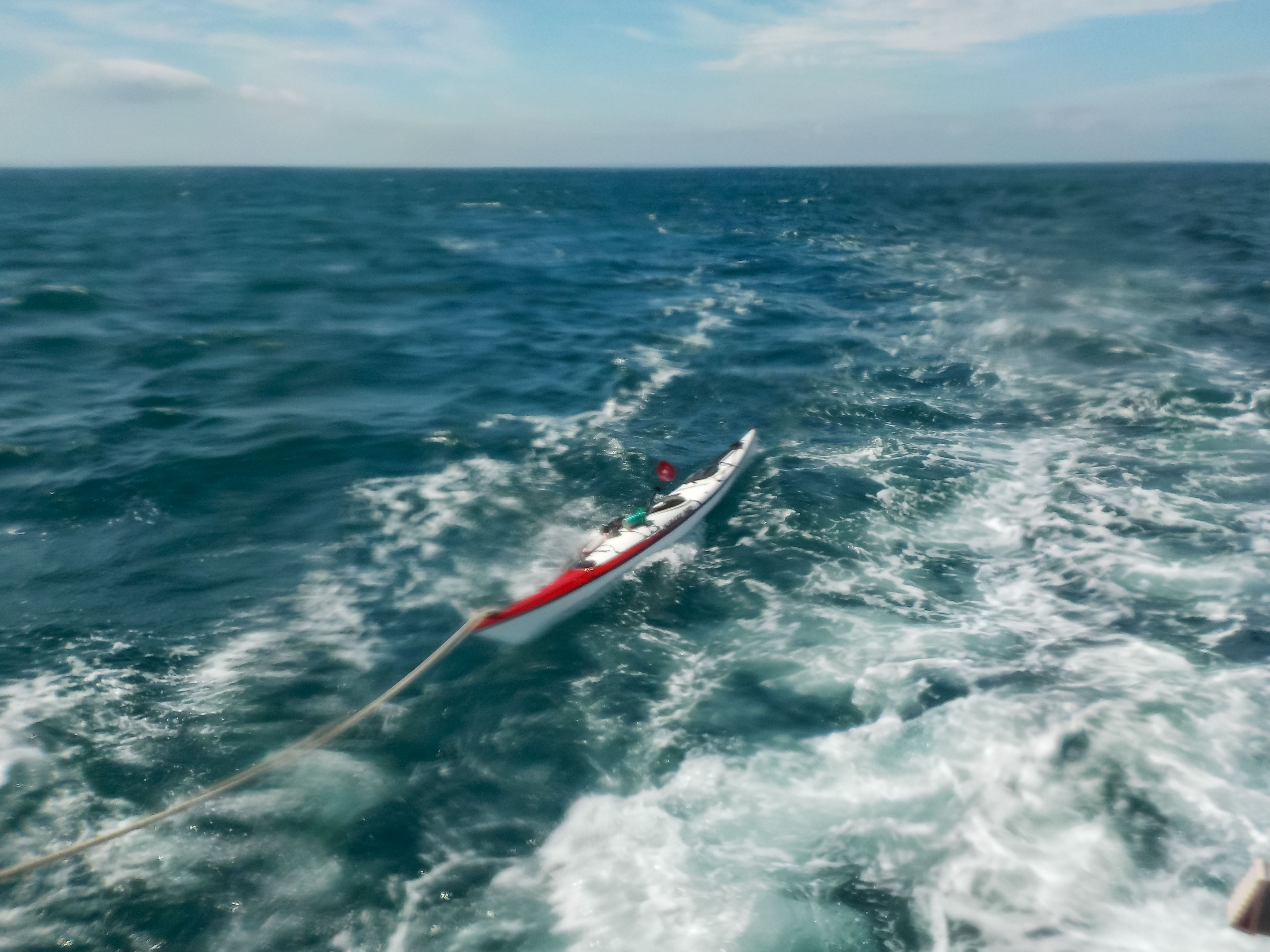
As luck would have it the wildlife tourist ferry Brianna Lee from Port Welshpool was doing its daily run to the Light House. They had seen me and motored alongside. The skipper kindly took my kayak in tow with me on-board and dropped my off at Horn Point, which was where the others had by this time got to. It must have been a good kilometre to land (upwind).
Towed back in by the wildlife tour ferry – Brianna Lee
They dropped me off at Horn Point
The rescue definitely saved me many more hours on the water. I have often thought of how this would have played out if I wasn’t rescued by the Ferry. I had sufficient water and food for two days along with a marine radio, GPS and PLB (Personal Locator Beacon). Firstly I would have performed an emergency self -rescue using my paddle float. I have trained in self rescue with a paddle float in similar conditions and am confident that I could have got back in my boat. My technique is to do a re-enter and roll using the paddle float, and then use my electric bilge pump to pump the cockpit dry. In this scenario I would have been over a kilometre from land. I would have soon realised that paddling upwind in a 25 knot wind to get to Wilsons Prom would have been “touch and go”.
Late afternoon Day 2: : Looking south across Refuge Cove from Horn Point towards Brown Head. We camped at this location – too windy to paddle to Sealers Cove! The sea appears calm in this photo but quite different in reality.
Would Steve, Peter and Derek have put themselves at risk and paddled out to sea to get to me? This is a good question which would have depended on when they noticed I was missing, when they noticed the ferry on the scene and various other factors. As it was they had a strenuous battle upwind to get themselves to safety which was a real effort in itself!
In the scenario of being by myself with an off shore wind, increasing to 30 plus knots by 2pm, I would have firstly faced the shore and monitored my paddling progress against the wind. If I was making 1 or 2 kilometres per hour headway I could have possibly been successful in making the distance over a few hours. I must experiment one day to establish my limits in this regard. The only other option (apart from activating my PLB) would be to strike out towards the Seal Islands (19 km to the NW), or Hogan Island (47 km to the SW). I have paddled to, and camped at, both these locations before and had the way points programmed in my GPS. If I would have taken the Seal Island option the wind would have been on my port quarter or what’s described as a broad reach – this would have taken approximately 3 hours to paddle. To Hogan Island the wind would have been on my starboard quarter (broad reach) and taken approximately 7 hours of paddling. Therefore I would have hopefully reached either landfall by dark. I had camping equipment, food and water for a few days so this wouldn’t have been an issue. It would have been important to contact friends and family as soon as possible. If I couldn’t raise anyone using my VHF radio whilst on the water I would have had mobile phone coverage on both these islands (tested on previous occasions).
The event was quite embarrassing at the time, but was also an invaluable experience. Lessons learnt:
Not to have the sail up when close hauling in strong wind conditions (20 knots off shore). Up hauling a sail in a kayak is risky.
Use your whistle immediately to alert others.
In remote areas every paddler should be independent and fully aware of their actual location. ie use map and GPS. Don’t solely rely on others.
Every paddler should have a marine radio (I think was the only one with a VHF radio).
Don’t rely on the BOM forecast. – wind speed was twice what was predicted.
Have the paddle float stored on the upper deck for quick and easy access. Consider getting a second paddle float in the event of spending a night on the water – making an outrigger/ sponson using your paddle strapped across the kayak deck.
Blue water Kayaking is for the adventurous person. The conditions we experienced on that day were demanding, and I ended up in a very precarious situation. This situation could have easily ended up with me getting blown miles offshore, as well as the other three. Once away from the coast it would be hard to predict if I/we could have effectively paddled upwind back to the Prom against 25 knot winds in three metre seas. With an off-shore wind the further away from the coast and protection of land the rougher it gets. On the whole I was extremely lucky to get picked up by a passing boat. Fortunately this incident hasn’t scared me from doing similar trips again. I consider myself to be much more learned as a result.
The Grampians Peaks Trail is one of Victoria’s proposed icon long distance hiking trails. The first section is now complete – a 38 km, 3 day/2 night circuit departing from Halls Gap.
Margie an I did the hike in Oct 2017. You can see a video of our walk via the link below.
We are looking forward to future sections of the trail being completed.
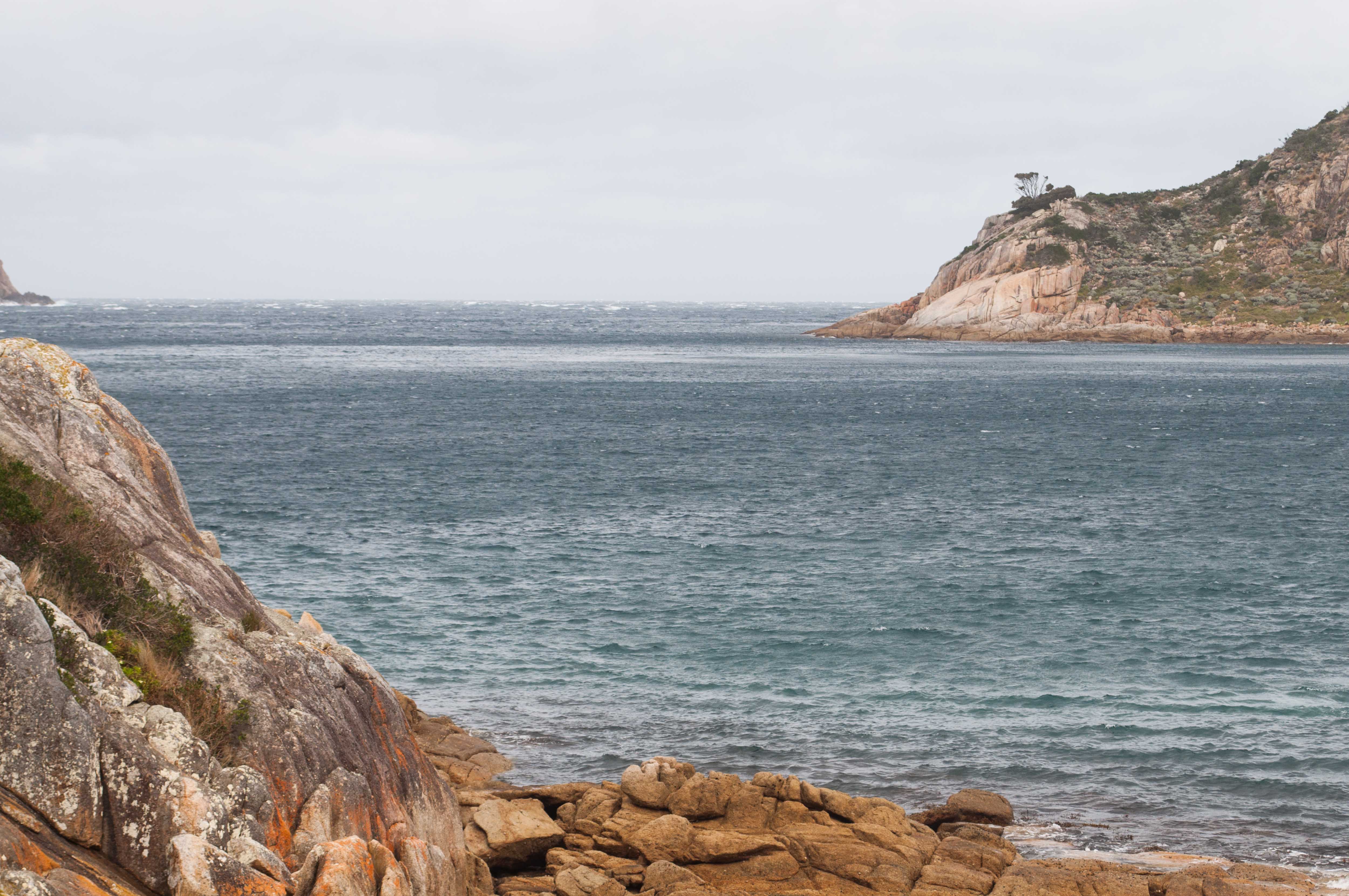
There is so much beautiful coast to explore around Wilsons Promontory National Park. Skull Rock, otherwise known as Cleft Island, is located in the Bass Strait about five kilometres south of the most southern point of the Park. I did a memorable return paddle to Skull Rock from Tidal River in April 2017.
I was lucky enough to see seals on this trip. They are captivating to watch in their home environment. Unfortunately there are not as many know as there once was. Early in the 19th century men flocked to the Bass Strait Islands to kill the seals which were valued for their fur and oil. Between 1800 and 1806, about 100,000 seal skins from Bass Strait passed through Sydney, and by 1820 the seals were almost completely exterminated.
Three different seals were originally present in Bass Strait: the Australian elephant seal, the Australian sea lion and the Australian fur seal: but only the fur seals still live there in very small numbers. The elephant seal and sea lion colonies were completely destroyed. The only way these two species will ever return to the Bass Strait is with a significant population growth at colonies south of Tasmania (elephant seal) and west from Kangaroo Island, South Australia (sea lion).
You can see a short video of my paddle via the link below.
A group of us from the Victoria Sea Kayak Club paddled from Port Welshpool along the east coast of Wilsons Promontory National Park, staying at Johnny Souey Cove. You can see a short (5 min) video of the trip at https://youtu.be/PBcOhY9_Gyk
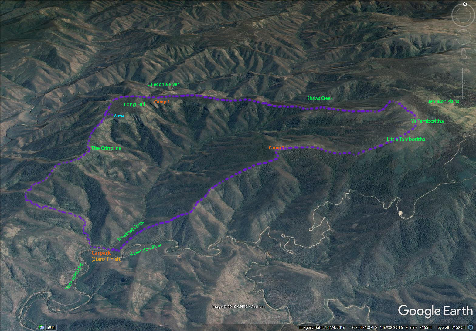
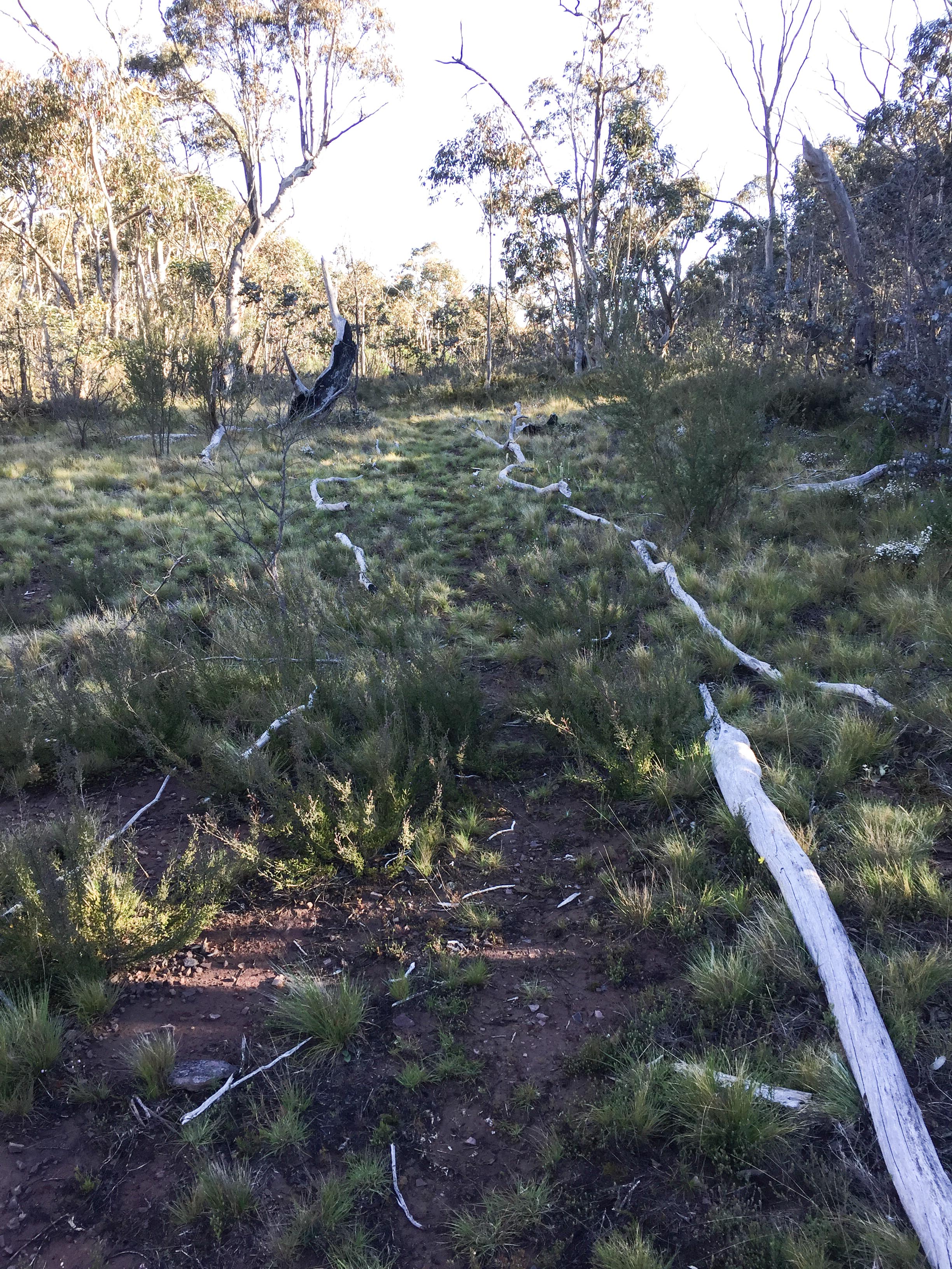
After descending the final 900 metres on the third day I had finally completed this walk – this was my second attempt. Two weeks earlier I set out to do this walk with Margie, however we were forced to turn back on the second day after it proved harder than expected and we weren’t equipped with water bladder/bags to carry sufficient water. See previous blog (Long Hill via The Crinoline – October 2016).
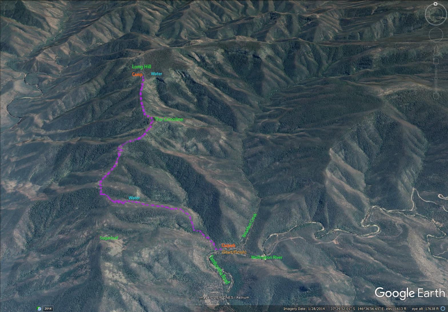
Map showing route walked. Click to enlarge.
I was keen to try this walk again and tick it off before the end of spring as I knew with summer fast approaching it would become even harder to find water and with the warmer weather you can’t walk far without water. This time Margie was happy for me to set out by myself. The main addition to my pack was a Sea to Summit 10Ltr water bladder.
DAY 1
I parked at the Breakfast Creek carpark, Tamboritha Road at 10am and had a steady climb to The Crinoline. This was good work out as the elevation went from 340m to over 1100 metres. A few times that morning I could hear a wild dog/dingo howl from the opposite ridge. This primeval sound made me think about the hardships of animals such as dogs surviving in this country and was one of the moments I love when walking in more remote parts of our bush.
Approaching The Crinoline
At The Crinoline
After a brief stop at The Crinoline I continued onto Long Hill. During the final few kilometres my thoughts were focussed on whether I would find water in Long Hill Creek? I’ve heard that during summer this creek completely dries up which is a real issue as it is a time and energy consuming walk to lower elevations to find water. If the creek could not provide me with water my three day circuit trip was over. Two weeks ago I could see water dropping over the falls from a good distance but this time was different. However when I got within a few hundred metres of the falls I saw a small shower. I was instantly relieved and knew that virtually nothing could now stop me from completing the walk.
Looking north towards Long Hill
A view back to The Crinoline
The creek was still flowing – I now had enough water to continue
After pouring 7 litres in the bladder I coaxed myself into walking a bit further. It was 3 pm – a bit too soon to stop for the day. From here on it was slower going. The absence of markers and onset of low cloud caused me to double check my GPS to make sure I was still on course. At about 5.45pm heading east on Long Hill plateau it got really foggy and I was struggling to see 20 paces ahead. On the plateau with no markers I was reliant on my GPS. At nearly 1300 metres elevation I didn’t expect the weather to improve so on finding a nice flat area I set up my tent. It was a good day’s walk. I had covered 15 km and ascended about 1200m.
DAY 2
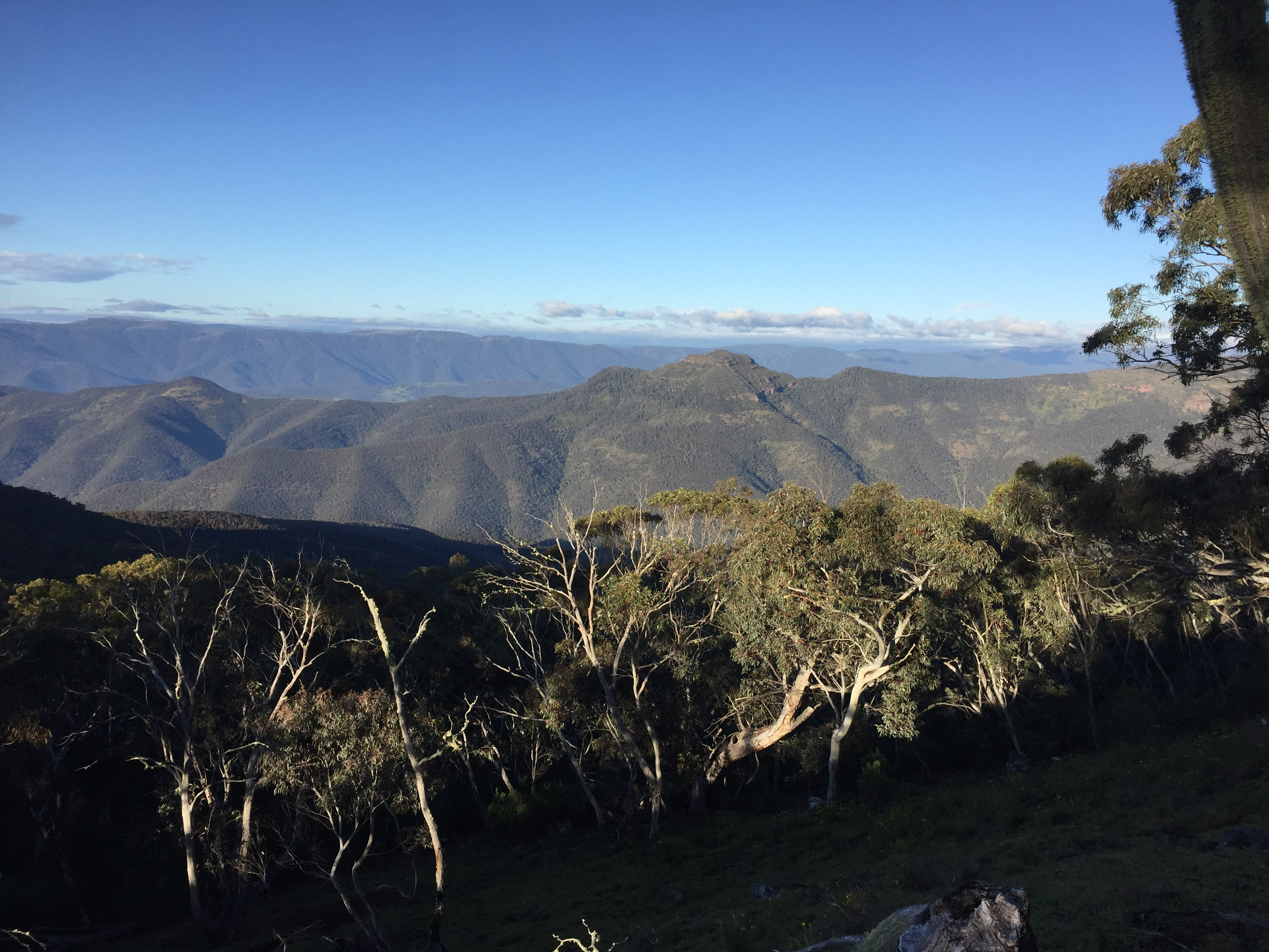
The next morning I was blessed with blue skies and amazing views across the Caledonia River and to the north. There were open faces stretching down towards the river and I’m sure in a remote and undisturbed place like this, with some time and patience, you would spot deer feeding well away from cover. Anyway photographing deer was not on my agenda on this trip so I kept moving.
A great spot to spend the night
Persons before me had gone to lot of trouble placing piles of rocks at strategic locations along the route. These rock cairns were the only visible marking system along the section between Long Hill and the Rock Shelter. Occasionally I missed a few rock cairns and ended up on the worst part of the ridge soon realising there must be an easier way. I then retraced my steps until the last known cairn and did a brief search until I identified the next stack of rocks. I was thankful that whoever originally placed the rocks knew the best way to avoid the most difficult terrain. Sometimes the route dropped 20 metres down the side of the ridge and at other times it crossed the ridge at right angles to go from one side to the other side. When there was a shortage of rocks the path had been lined with dead branches!
When there was a shortage of rocks someone had lined the track with dead branches!
Towards the Caledonia River
More views to the north
All the time there was a new inspiring view to look at. In contrast to the walk up to the Crinoline there were no unnatural blemishes in the distance such as cleared farmland. It was 9.15am and I was in one of the many saddles. What I thought was going to be an easy walk along a contour turned out to be a fair amount of up and down. I finally arrived at the Rock Shelter for a snack, drink and another fantastic view to the north. The trail was becoming more discernible and to my surprise a few hundred metres later it transformed into a 4WD track! Although there wasn’t much evidence of vehicle traffic I would have preferred a narrow walking track. Now for a steady climb towards Mt Tamboritha.
Bennison Plains and Shaws Creek in the background. From Mt Tamboritha.
After what seemed like ages I had reached the next intersection, McMillans Track (elevation 1370m). This took me over Mt Tamboritha with views to Bennison Plains, and down to a saddle before Little Tamboritha. By this stage I had covered 30 km, and with a total ascent of 2000 metres no wonder my legs were feeling tired.
I was also thirsty. Looking at my water situation was disconcerting as I barely had enough to last another day? On the first night I had used a couple of litres and so far that day consumed the same again. At this rate I was going to run short. My options were to drop down a gully and hope I didn’t have to go too far, continue on and tough it out, or take advantage of a number of constructed fire dams situated along the track. I came across the first dam on the saddle between Mt Tamboritha and Little Tamboritha. This dam like the next two I encountered must have been constructed over a decade ago before an existing track was downgraded to a walking track. If it was good enough to sustain frogs it should be good enough to drink. Although it was not currently being fed by a stream it had obviously been flushed during the winter/ spring rains and was still reasonably clear. I took a couple of litres and boiled it before drinking just to be on the safe side. There were no side effects. The next time I will take a water filter.
It was my intention to cover some more ground to make it a shorter day tomorrow so I walked past the last dam and camped on a nice grassy top at 1260 metres. I had walked just over 18 kilometres that day.
DAY 3
This was going to be a short day. The last seven kilometres was all downhill. Again there were very few markers with little or no track to follow. There was evidence there once was a track but it was now quite overgrown. One of the spurs was a bit tricky with a slight turn to the west before dropping off – if you went straight ahead you would have some bush bashing to do. With clear views across to The Crinoline so I could see where I had been two days earlier. Slowly I was descending and by looking in the distance I was able to compare my elevation with landmarks on Day 1. Leaving camp at 6.45 I arrived back at the car at 10am.
The Crinoline in the distance on day 3.
If you were really fit and didn’t mind pushing yourself you could do this walk in two days but personally I don’t think it would be enjoyable. It’s better to take your time and absorb the scenery and natural wonders. This walk is in remote country on mostly unconstructed tracks with limited marking. There is a fair bit of steep walking and uneven ground. This is a great walk for improving your level of fitness, planning and navigation skills combined with beautiful scenery. It had a bit of everything.
What was going to be a three day walk was cut short. Our original plan was to complete a circuit walk starting from Breakfast Creek car park and finishing at the same location, however the first day was harder than expected and with a few uncertainties, including the unknown conditions ahead and availability of water, we took the safe option and turned back. On the positive side this was a good recce for a future walk when we would be better prepared.
The Saturday (29 October) was essentially all up with an ascent of 1020 metres over 10.5 kilometres and the Sunday down in reverse.
Map showing route walked. Click to enlarge.
DAY 1
The first 4 km, from the car park to Sugarloaf ridge, was a steady climb along a well formed track gaining an altitude of 500 metres. This was a good heart starter and in the warm 25 degree October sunlight I could feel the sweat forming. We topped up our water bottles 10 mins earlier after hearing water trickling in the creek near the track (it should be noted that this water supply is very intermittent). We then had two litres each which would serve to keep us hydrated until the next water opportunity at Long Hill.
Margie at the start of the walk.
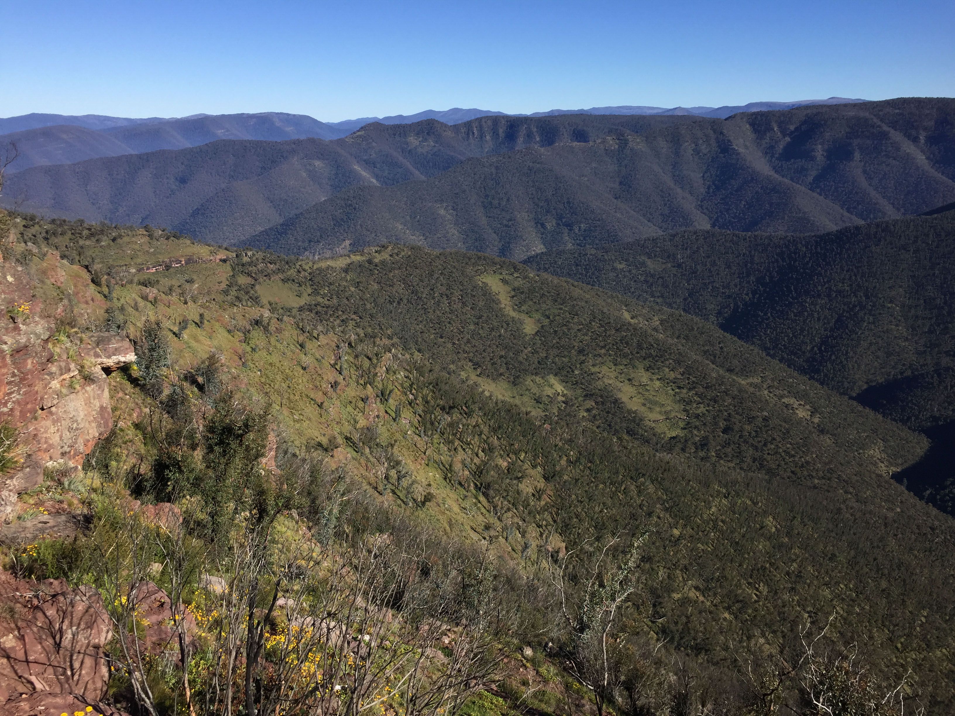
Then we had a steady stroll for 15 min before a steep climb up a grassy slope with numerous switchbacks. The track was becoming narrower all the time – it could be better described as an animal trail. As we looked behind us we had views of the Sugarloaf, a quaint picturesque hill to the south. At the top of the slope the track gave way to rocky ridge to The Crinoline. At 6.7 km (from the car park) we stopped at the side of The Crinoline for a relaxing cuppa whilst taking in the views of the expansive Wellington River Valley. Travelling from home that morning meant we didn’t get started until 1pm and given that the afternoon was fast disappearing we thought we had better get a wriggle on to ensure arriving at our camp site on the Long Hill prior to dark.
The Crinoline ahead.
Views to the East from The Crinoline. Click to enlarge.
A selfie at The Crinoline.
Some orienteering was required on the NW face of the Crinoline as it looked easier to skirt around the face rather than going up and over. We simply stuck to a contour just above one of the upper rock tiers and managed to avoid most of the shrubs. Then it was an hour plus of boulder/ rock scrambling and gentle walking for the next 3 km before reaching our camping spot for the night.
Traversing the NW face of The Crinoline
The route from The Crinoline to Long Hill.
It had taken us longer than expected. Margie in particular was feeling fatigued from the ten plus kilometres walk and thousand metre ascent. We arrived at the tent site just before dark and quickly dropped our packs to walk down the gully to Long Hill Creek for water replenishment. Fortunately there was a nice flow of clear water at the headwaters of the Creek just above a waterfall. We could see that others had accessed the creek as there was a discernible path from the main walking track. Someone had marked “water” with an arrow on a rock to show us where to turn off the main track.
We replenished our at Long Hill creek above waterfall. Seasonal flow only.
This was a bigger day than expected. To continue on might have been unwise as Long Hill was likely the last practical water access for the next two days! I had thought that we would simply drop into the head of a gully at our next camp but not having local knowledge or good information on water sources could have put us in trouble. Upon realising the lack of a constructed track and difficulty of finding water, and our lack of carrying sufficient water, we made a decision to turn back.
Our camp site.
DAY 2
We got up at day break and made a quick visit to the creek to refill our water bottles. The weather conditions were deteriorating with strong winds forecast. Before daybreak there were strong wind gusts. Fortunately our Big Sky Chinook all season tent was proving resilient on the exposed site. With the wind getting stronger we packed up and were on the way by 7 am.
The Crinoline early on Day 2.
We soon made it to The Crinoline but had to take it slowly traversing the north west face as the wind was really packing a punch. We both had our hats blown off and had to scurry after them. Walking on the tops of the boulders and rocks was precarious and we occasionally had to stop and brace ourselves until the gust had passed. We were thankful to drop lower into the shelter of Breakfast Creek. A few drops of rain with what looked like worse to come. We got back to the car at midday.
Although we didn’t complete the full circuit we still had a great experience in some very nice remote country. We will certainly be better prepared next time when walking in this part of the Victorian high country. The main thing is to be self sufficient with water. There are a number of walks that have similar water challenges in Victoria including the Crosscut Saw section of the Australian Alps Walking Track. Carrying water for two days can be demanding as most of us prefer to travel light, however this appears to be a necessity for this walk.
I was given an opportunity to join an overnight rafting trip down the Mitchell River. I hadn’t been rafting before so I was keen to give it a go. All up there were five rafts and four white water kayaks in the group. Mitchell River is popular for rafting and kayaking, with long flat sections interspersed with large rapids.
We launched at Angusvale (Mitchell River Project Access Rd) and paddled to Final Fling (Alexanders Rd). This was roughly a distance of 30 km over the two days. We camped about half way.
Amphitheatre Rapid was one of the highlights of the trip. We tackled it on our first day. Unfortunately we didn’t get a good start. A small stopper had turned us around to face the wrong direction and upset our chosen obstacle free downstream ‘V’ path. Our raft flipped at a big stopper moments later. The four of us were flung out and went for a nerve-wracking swim.
Emma and Holly managed to catch a throw bag from the guys along the shore. I got hold of the raft grab loop and stayed with the raft until it stopped against a big flat rock two thirds of the way down, whilst James missed the throw bags and got swept downstream past the rapids before finally making it to the bank. Even with a PFD you can sink and it seemed to take ages for me to come up after the initial dunking.
Amphitheatre is a Grade 3 rapid. However, given the level of 1.85 metres on the day it was probably a Grade 3+. Apart from our guide getting a cut above his eye we escaped injury. I lost a bootie and water bottle. Two paddlers in a following raft got thrown out but kept hold of the safety OS line running around the outside, and were quickly dragged back in. All our paddles were collected downstream at the first flat section.
This trip made me really appreciate the challenges of rafting, such as reading the water, working as a team and deciphering the safest path.
See my short Video of the Amphitheatre Rapid at https://youtu.be/xhB6o9IzG84 (footage from my helmet mounted GoPro).
It had been two years since my previous back pack trip into this amazing part of the Alpine National Park (See post – Stalking Sambar with a Camera, Sept 2014).
Doug taking it slowly – day one.
Doug, my brother-in-law, joined me on this trip. Doug, like me, enjoys bush walking and outdoor adventure. This was an opportunity for Doug to see Sambar in a scenic and rugged landscape. He was keen to take his firearm with him as part of the experience. Being physically fit and feeling at ease in a remote area away from roads and tracks is a pre-requisite for this type of activity. It does not appeal to everyone. There are risks and hazards with potential for slips, trips and falls. We took it slowly when negotiating rocks, steep slopes and loose ground. It helps if you are sure footed with a good sense of balance. If you sprain a knee or ankle it would be extremely tough going to get back to the car. We did some fitness training leading up to this trip including an overnight walk with all our gear. This also helped us test our equipment and explore ways of keeping our pack weight down to a minimum. Lugging in a big lens and tripod wasn’t easy for me but I suppose it’s akin to Doug taking his firearm. Our intention was to be away from the car for five days so planning for food and provisions was important. Water was scarce on the way in so we had to carry sufficient water to last for a day or more.
After what felt like ages back packing we arrived at our campsite – mid-afternoon.
The stag was still bedded down at 5.30 pm!
We closed the gap to 120 metres
Glassing with our bino’s from the camp site soon revealed a deer. A young stag was bedded down on the opposite face quite a distance away. He was partially hidden behind a mound of earth -we could only see his head protruding to the side. We quickly set up our campsite, donned our day packs with torch and snacks, and set out to try and get a closer look. It took us over an hour to get directly opposite the stag. He was still bedded down, which was unusual given it was 5.30PM! After some stalking through a patch of Casuarina we managed to close the gap to 120 metres before he sensed our presence, became unsettled and moved off. I was lucky to get a photo as he stood up. By this time the sun was setting. Having dropped a few hundred metres in altitude from our camp, down rocky escarpments and through steep gullies, it wasn’t until well after dark when we returned back to base. Travelling during the night is when our GPS proved itself once again and I’m sure it saved us considerable time. We were both exhausted after our big day and questioned whether we had crammed too much in. However, we couldn’t resist the urge to get a closer look at this stag!
Doug glassing for Sambar from a good vantage point.
The next day, after a leisurely start, we explored along the river. We saw a few deer during the day but nothing worth following up. On the third day we walked for miles up a tributary and through some interesting and promising country, however it didn’t produce as much as we were hoping. We got honked at in the morning, watched two hinds for a while wandering around on a distant face near midday, and later stumbled onto a small stag bedded down in a rocky spur on the way back that afternoon. I wasn’t quick enough with the camera as he quickly dropped down behind low scrub and rocks. We later filled up our water bladders at a side creek before the steep climb back to camp.
Scarlet Robin – male.
Scarlet Robin – female. Both photos taken at campsite.
On day four we dropped down to the river just after daybreak and were pleased to observe a number of deer on the opposite face across the river. I reckon they had returned from a nightly feed on our side of the river.
1st Stag in morning of day four (250 metres)
2nd Stag in morning of day four (120 metres). Missed getting photo of 3rd stag.
We noticed two stags well apart from each other along with a number of separate hinds. The farthest stag was 250 metres away with the closer stag half that distance. All I could see of the closer stag was the rear section of its body with its head obscured by a tree. In an effort to get a better photo I sidled to the left. I knew this was risky as deer can easily pick up lateral movement. The safest technique to get closer to a deer is in a straight line between you and the animal. However I had no choice but to go sideways in what was fairly open country. I eventually got to a good position for a photo. No sooner had I clicked the shutter I noticed a flash of a much bigger Sambar with large antlers about 10 metres behind the younger stag. Obviously the more mature animal was keeping watch for danger from the safety of cover. When it identified me and felt threatened it took off. I was hoping it would cross a couple of open clearings on its departure but being as smart as it was it kept to a narrow strip of thick vegetation as it climbed its way up the face, with the younger stag following. We crossed the river and gained some height but did not pick them up again. It’s always much more difficult stalking when you’re on the same face as the deer.
Sambar hind – photo taken on day 4.
After a few hours walking we gained some altitude as we headed into a new gully system with steep faces reaching up to the clouds. There were a series of sweeping horizontal rock fault lines making the terrain all that much more challenging. We separated and kept in touch via our two way radios. Our intention was to poke our way along the side of the face hoping to see some animals. That was until Doug said on his radio “I’ve just spotted a hunter on the opposite face”. Doug at this stage was a few hundred metres above me. After a few minutes of searching I picked up a hunter wearing a blaze orange hat and Moroka 30 half blaze hunting shirt. He must have been at least a kilometre away as he was just a dot on the landscape. If it wasn’t for a couple of deer we were keeping an eye on in the general location of the hunter we wouldn’t have spotted him. We then noticed another hunter following the same line about half a kilometre behind the first hunter. They were well ahead of us on the opposite face heading in the same direction. We heard a few deer honk well up ahead so they had obviously caused alarm amongst some of the deer. Soon after the first hunter left our field of view we heard a shot. It must have been from the first hunter as we were watching his mate at the time. We then made the decision to turn around, not knowing if the other hunter was successful or not.
It doesn’t matter where you walk in the Victoria High country these days you are never far away from deer hunters. More and more hunters seem to be back packing into remote areas in search of a good hunting experience. This part of the Alpine National Park is open to hunting 10 months of the year. Even though I am taking pictures I am concerned about my safety and always wear a high vis blaze orange hat in this back country.
Two Sambar bedded down. Note deer facing opposite directions for 360 degrees lookout.
Something we heard nearly every day on this trip was wild dogs. We were hoping to catch sight of them but they were too smart for us. I remember one afternoon, as we were watching a couple of hinds bedded down, the dogs situated less than 400 metres at an angle away from the deer (and us) started howling. It was interesting to see their reaction to the dogs. I was expecting the two deer to get up and get some distance from the dogs; however they stayed where they were. After 5 mins of howling the dogs went quiet. The Sambar were still bedded down! I can only surmise that they were used to living in proximity with wild dogs and because they were fairly mature size Sambar, did not see the dogs as a threat.
The advantage of this type of country is that you can spot Sambar a good distance away, but stalking close enough for a good sharp picture is often not practical due to the difficult terrain. I found that once you get on the same face as the deer you need everything in your favour including visual contact and a quiet approach. Getting closer than 100 metres is rare. The normal situation is to have a river, creek or gorge between you and the deer, which can take more than an hour to cross. By that time the deer have moved on. This country is more suited for long range photography.
On the way out after five days.
Another very enjoyable trip. It was very physically demanding but well worth the effort.
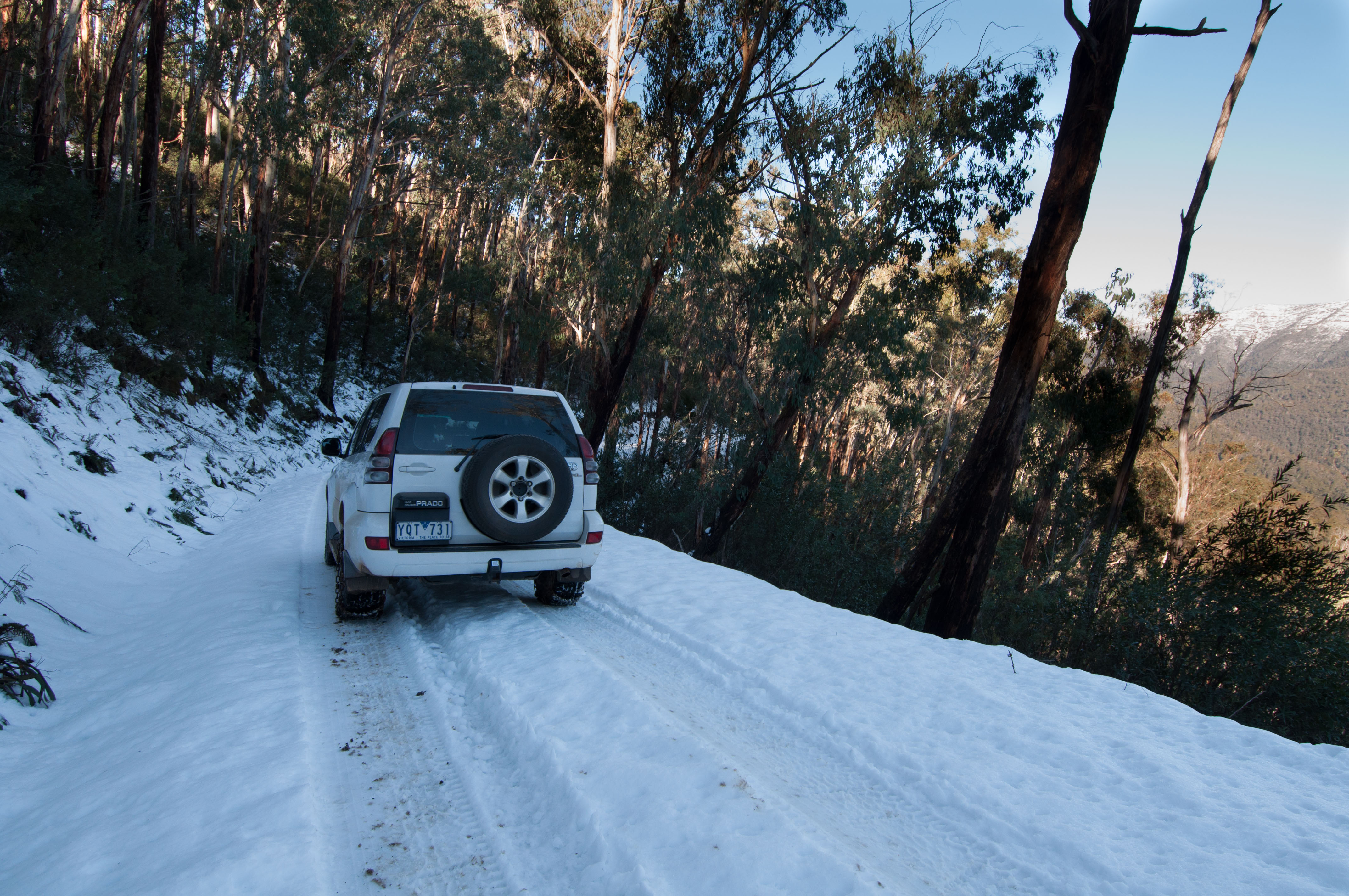
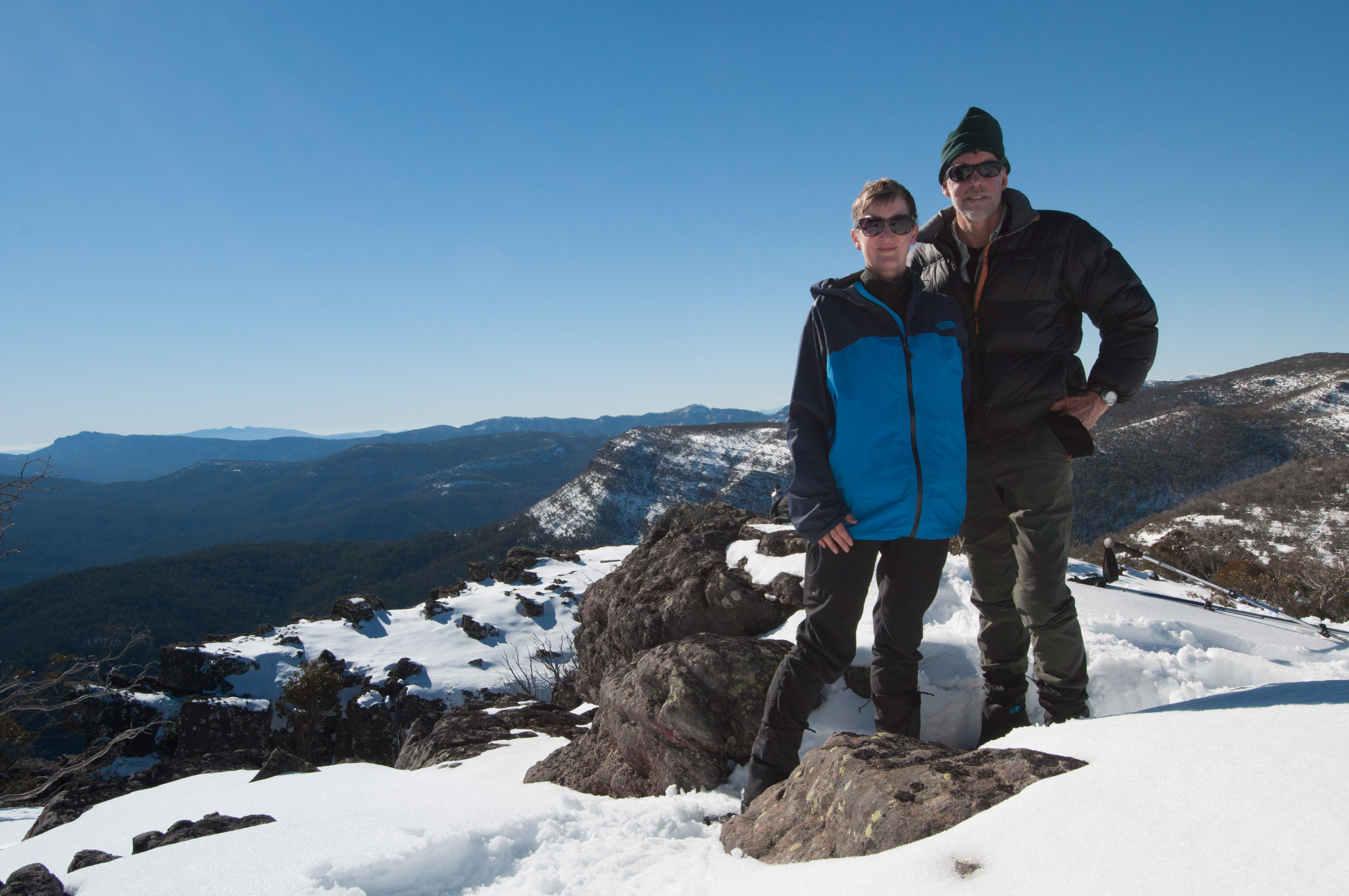
In mid-July 2016, after 30 cm of snow had fallen that week, my wife Margie and I decided to go snow camping in the Alpine National Park. On the Saturday morning we loaded our back packs, snow shoes and gear into the Toyota Prado and headed for The Bluff. The Bluff, at 1714 metres, is a spectacular rocky plateau situated in the Victorian high country east of Mansfield. I had not been there for two years since doing an overnight walk towards Mt Howitt with Joe, my youngest son (See: Towards Mt Howitt – Winter 2014). I was looking forward to this trip with Margie as it would be her first snow camp.
Our start was delayed on Saturday due to Margie’s work commitment so it wasn’t until mid-afternoon when we hit the intersection at Eight Mile Gap (10 klm past Sheepyard Flat/Howqua River). Because of the recent dumping of snow a number of drivers had decided to not risk driving further and had parked their cars at Eight Mile (1092 m). We fitted our snow chains to the Prado, and continued on towards Refrigerator Gap. After a few kilometres we came across a Subaru which had pulled over due to the depth of snow and low ground clearance. We then passed more vehicles parked with similar clearance issues. They consisted of XC skiers and a group from the Victorian Climbing Club on a mountaineering training weekend.
Driving beyond Eight Mile Gap to Refrigerator Gap car park.
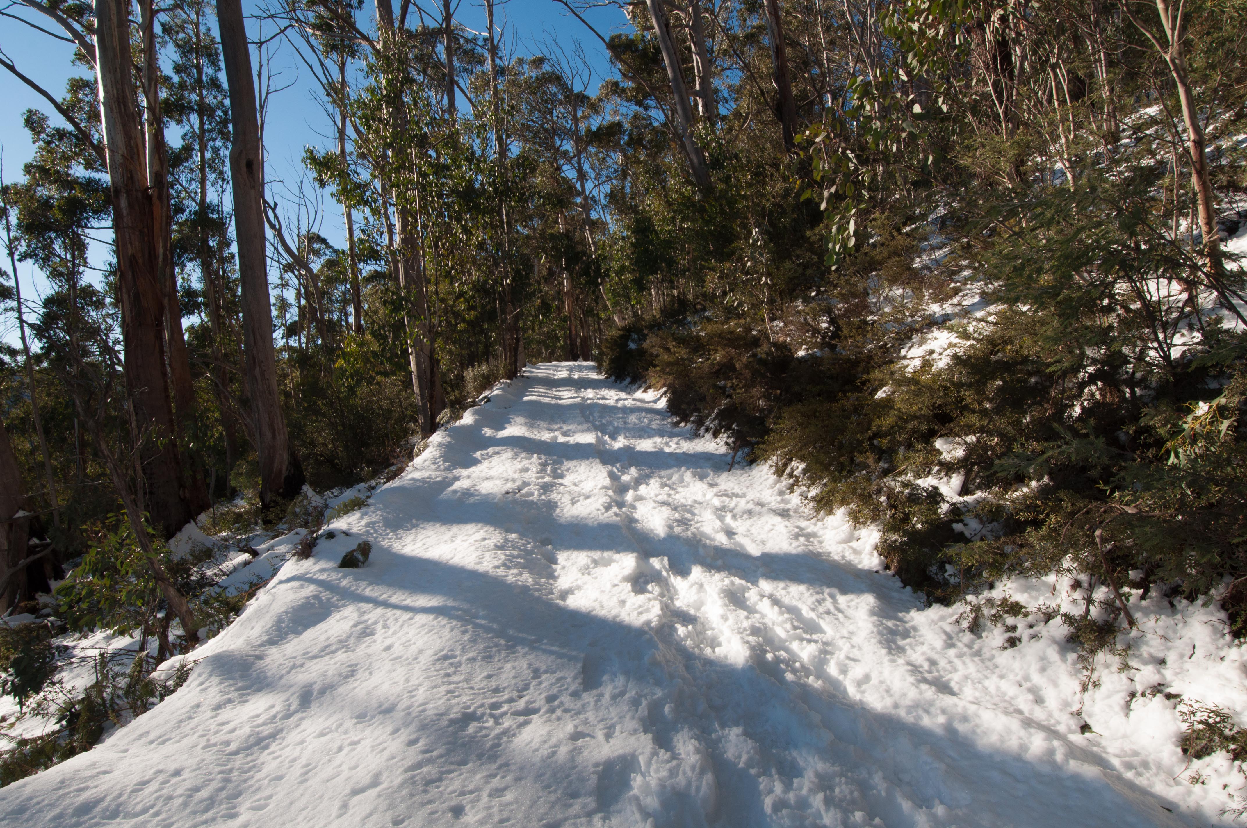
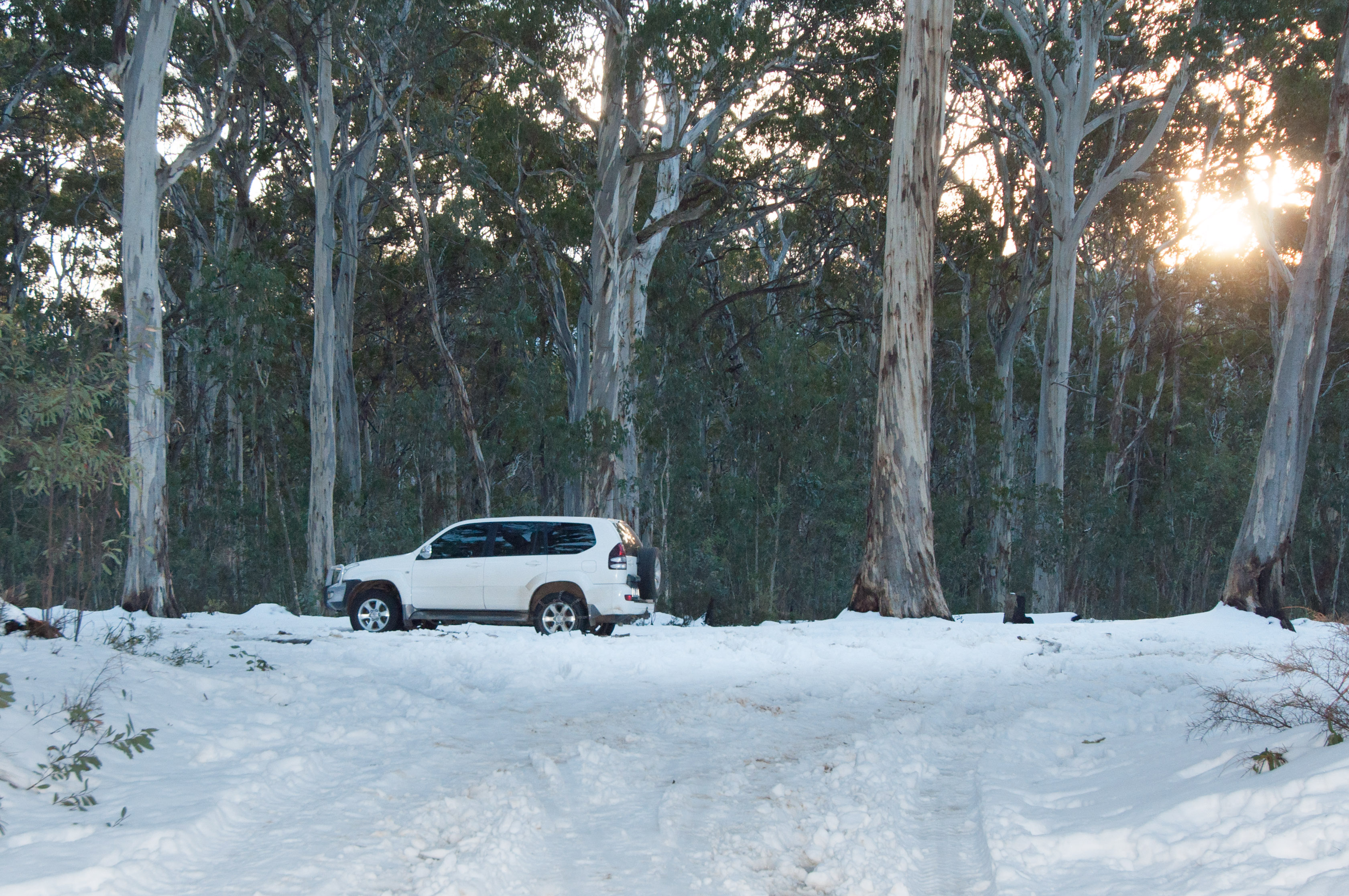
We were intending to drive as far as the seasonally closed gate on Bluff Link Track below Bluff Hut, however we were forced to park at Refrigerator Gap carpark (1260 metres) due to the amount of snow and difficult track conditions. Only one serious 4W driver with a modified vehicle had risked to travel beyond this point. Stopping at the Gap carpark meant an additional 6 kilometres walk. By heading off at 4 PM we weren’t going to get far before dark. We were originally hoping to walk to Mt Lovick and camp but the day was getting on. We now decided to walk about 5.5 kms before camping for the night and then walking to the Bluff Hut in the morning.
At the start of our walk
The sun was getting lower.
4 kilometres into our walk.
Fortunately it was a full moon night with clear sky so it proved light enough to continue our trek after sunset without the aid of a torch. The walking was relatively easy. In the early evening we set up our tent at 1280m under the light of the full moon, about 500m before the Bluff link Track gate.
The next morning we walked to the gate and a further two kilometres to the Bluff hut (1500m). The weather was perfect with a bright sunny sky. Our plan was to walk to Mount Eadley Stony and either return via the way we had come, or continue onto The Bluff and do a circuit back to the car via the Refrigerator Gap walking track.
Not far to The Bluff hut.
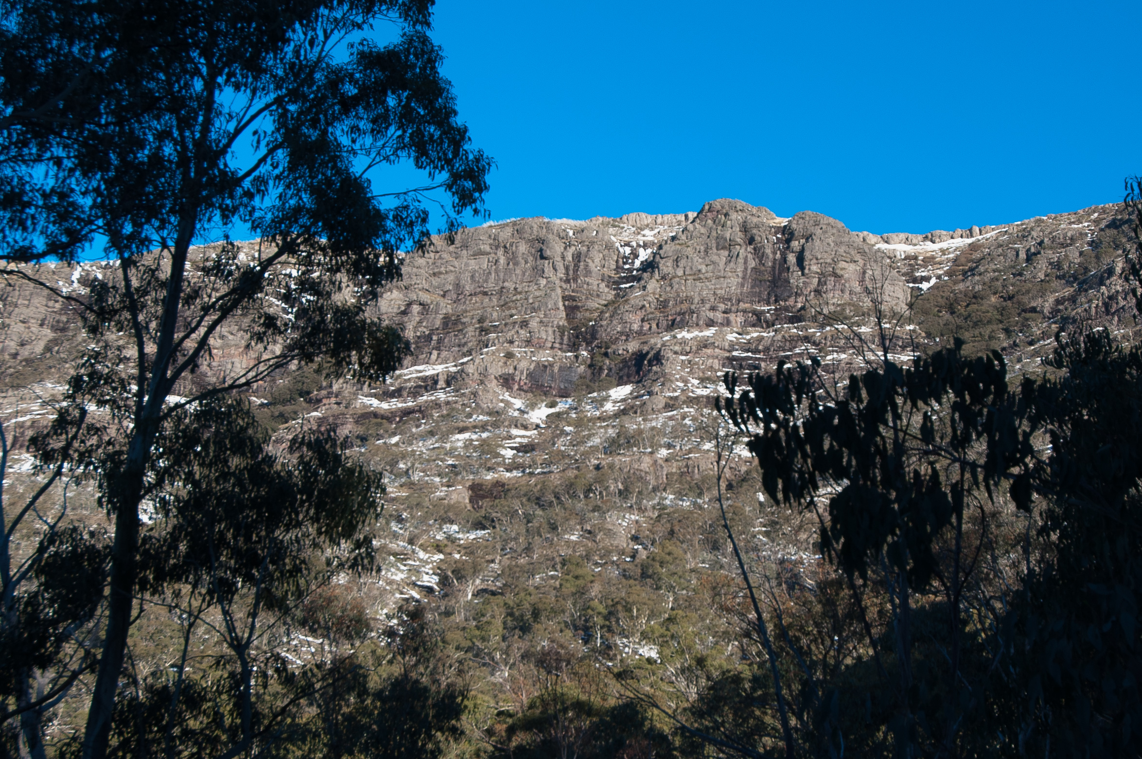
At the hut we encountered three other skiers who had spent the entire previous day travelling via The Buff and Refrigerator Gap walking track. They said it was a difficult climb up the steep track to The Bluff from the Gap car park and advised that a walk down the face would be considerably risky in these current conditions. The skiers had decided to go back to their car via the Bluff Link Track. They convinced us to do the same. Not aiming to spend another night out we decided to explore the nearby Mount Eadley Stoney and return back the way we had come. The 1 kilometre walk up to the top of Eadley Stoney from the hut was most pleasurable with breath-taking views at the top (1662 metres). We could see the snow-capped Mt Howitt to the north, Mt Buller to the west and Mt Darling to the east.
At The Bluff hut.
The view from Mount Eadley Stoney. Looking towards Mt Lovick.
The weather was perfect.
Even with good MSR Evo Ascent shoes we found ourselves sinking deep into the extremely soft powder snow. It was a different experience to walking on the more granular and crusty snow of the previous 2014 trip. Obviously it was a wise decision to not continue along the loop circuit as it would have been very slow going and challenging particularly during the descent down to the Gap carpark.
The west face of The Bluff – photo taken not far from the car park.
Back at Refrigerator Gap car park.
The walk back to the car from Eadley Stoney was 9 kilometres. In addition to the 3.5 kilometres walked earlier that morning we did a healthy 12.5 kms of snow shoe walking for the day. After having lunch at the Bluff Hut on the way down we arrived back at the car at about 5 PM. We were the last to leave the mountain.
During the previous week 30 cm of snow had fallen. The recorded snow depth was 55 cm (based on records at nearby Mt Buller). This compared to 109 cm at the time of our 2014 trip. Although the snow was only half the depth compared to my previous trip it was more difficult to traverse as it was very powdery and had not consolidated from the thawing and freezing process. Overall it was a great weekend and we look forward to returning one day soon to this wonderful part of the Victorian Alps.
This was our second family summer holiday at Mount Kosciuszko National Park. Margie, Joe and I left home on Boxing Day afternoon 2015 and camped that night near Cann River. We could have done the trip to Thredbo in about 8-9 hours but decided to do the driving over two days. Jack, our eldest son, chose to stay at home this summer and catch up with his mates. The following day, after stopping at the busy tourist town of Jindabyne for some last minute shopping, we arrived at Ngarigo camp ground in Kosciuszko National Park around midday. Ngarigo was a different camping location to the previous year but because Margie’s brother Michael and family – wife Paula, and three kids, Willem, Tessa and Evie, were camping there, and it was a scenic spot close to the river with ample recreational opportunities, we decided to join them. It was also free camping which was an added bonus.
Camped at Ngarigo
The Thredbo River
We conveniently parked our Jayco Dove next to Michael and Paula’s Jayco Expanda. Joe and Willem were focussed on riding their mountain bikes on the Thredbo downhill/flow trail. With a chair lift ticket they could spend an entire day getting lifted to Eagles Nest Restaurant at 1937m and riding at break neck speed down to Thredbo Village (1370m). The only thing that slowed them down was sore arms and for Joe a flat tyre.
Walking is always on the agenda. On the previous holiday we did a family day walk to Mount Kosciuszko summit – from the top of the chairlift. This year we wanted to do a slightly different day walk with good views combined with an element of fitness training. The Merritts Nature trail sounded appropriate. Our plan was to walk up the Trail starting from Thredbo Village through different vegetation types and scenery arriving at the Eagles Nest restaurant (Australia’s highest restaurant). The Eagles Nest also happens to be at the top of the Thredbo Kosciuszko Express chairlift. Our plan was to walk to the top and then catch the chairlift down. No tickets were required for the return journey. Michael was intent to take his mountain bike with him on the walk up so he could ride back down.
At the start – Margie,Tessa, Evie, Paula and Michael
We organised ourselves with water and snacks for the steep and continuous ascent. We set off about 10 AM in the morning. The weather was in the high teens and not too hot. The Trail follows the native bushland to the east of the chairlift. Most walkers catch the lift up and walk down the Trail doing the circuit in a clockwise direction. We wanted to do it the opposite way, primarily because it would be more challenging and rewarding, and not costing more than a few dollars (for a cuppa at the restaurant).
So off we went. After winding our way around the Bob Sled we entered a cool gully with a crystal clear water tumbling over the rocks. This was a perfect place to cool down and take a break. The Trail was about 4.0 kilometres in length, climbing over 560 metres in altitude, so it proved to be quite strenuous. We were mostly in the shade for the lower part of the walk. We passed through some nice stands of mature messmate stringy bark which survived the bushfires of a nearly a decade ago. There was stark evidence of the trees killed by the 2007 fires in close vicinity.
More steps
I reckon by half way up Michael was wondering if bringing his bike was such a good idea as he spent much of his time with it on his shoulder lifting it up the numerous steps! Margie, Paula and the two girls were doing fine taking in the scenery and enjoying the physical activity. As we got higher we started to experience the change in altitude as it became slightly harder to catch breath after a continuous grind up a long section of steps. Great aerobic exercise to say the least . At the two thirds point we were all asking how many more steps? I had done this particular walk by myself 12 months earlier, but my memory was vague on the extent of steps. My statement of “not many more steps” seemed to be a re-occurring theme.
L-R. Paula, Evie, Tessa, Michael & Margie.
About 2 hours into the walk we criss-crossed a service track. At this point Michael departed company and detoured hoping for an easier way to the top. Half an hour later we emerged at the Snowgum Chair to intersect the start of the bike downhill track and met Michael waiting for us – he wasn’t lost as we thought. We were now quite close to the top.
As we gathered together a rider on a mountain bike stopped to ask Michael in a somewhat officious tone where his helmet was. Michael had left his helmet with Paula in her day pack. Michael nicely explained that he had pushed his bike up from the bottom and that he was about to get his helmet from his wife who was only moments away. The rider voiced his concern about Michael not paying for a lift ticket as riders riding the trail are apparently required to do. He then told Michael in a provoking manner that he wasn’t to ride but push his bike down. Michael stayed calm and common sense prevailed with an acknowledgment that in the future Michael must pass the mandatory rider briefing and purchase a ticket before riding on the track. He then left.
Alpine landscape near the top
After this interlude with a member of the downhill bike riding fraternity we resumed our walk to complete the last three hundred metres to the top. 10 minutes later we reached our destination at the top looking out over the valley and mountains beyond. We sat down in the restaurant nicely relaxed with a cuppa and took in the atmosphere with a satisfying feeling of accomplishing a hard walk. Michael waited for Willem to come up on the lift to join him for the ride down. Unfortunately our son Joe was stranded at the bottom with a flat tyre.
At the Eagles Nest Restaurant 1937m.
What a great experience the walk was, and to have the convenience of a restaurant with outstanding views at the finish. Camping with the family in Mount Kosciuszko National Park, close to Thredbo, with its numerous walking opportunities, activities and amazing scenery is a great way to spend a week in summer. What an ideal location Ngarigo camp ground proved to be. We are yet to discover a place in the Victorian high country that offers a similar range of family experiences.
Celebrating at Wildbrumby Schnapps distillery and Cafe, Jindabyne.L-R. Michael, Margie, Me, Joe, Willem, Evie, Paula & Tessa.
A video showing some footage of the 2015 Vic Sea Kayak Club AGM held at Cape Paterson in Nov 2015.
There were a variety of trips, workshops and training options available over the weekend, as well as guest speakers. The planned Cape Paterson to Inverloch paddle on Saturday was cancelled due to rough weather. Instead we transported our kayaks to Inverloch and did a paddle near Anderson Inlet. On Sunday I joined a group to do a leisurely paddle from Inverloch boat ramp.
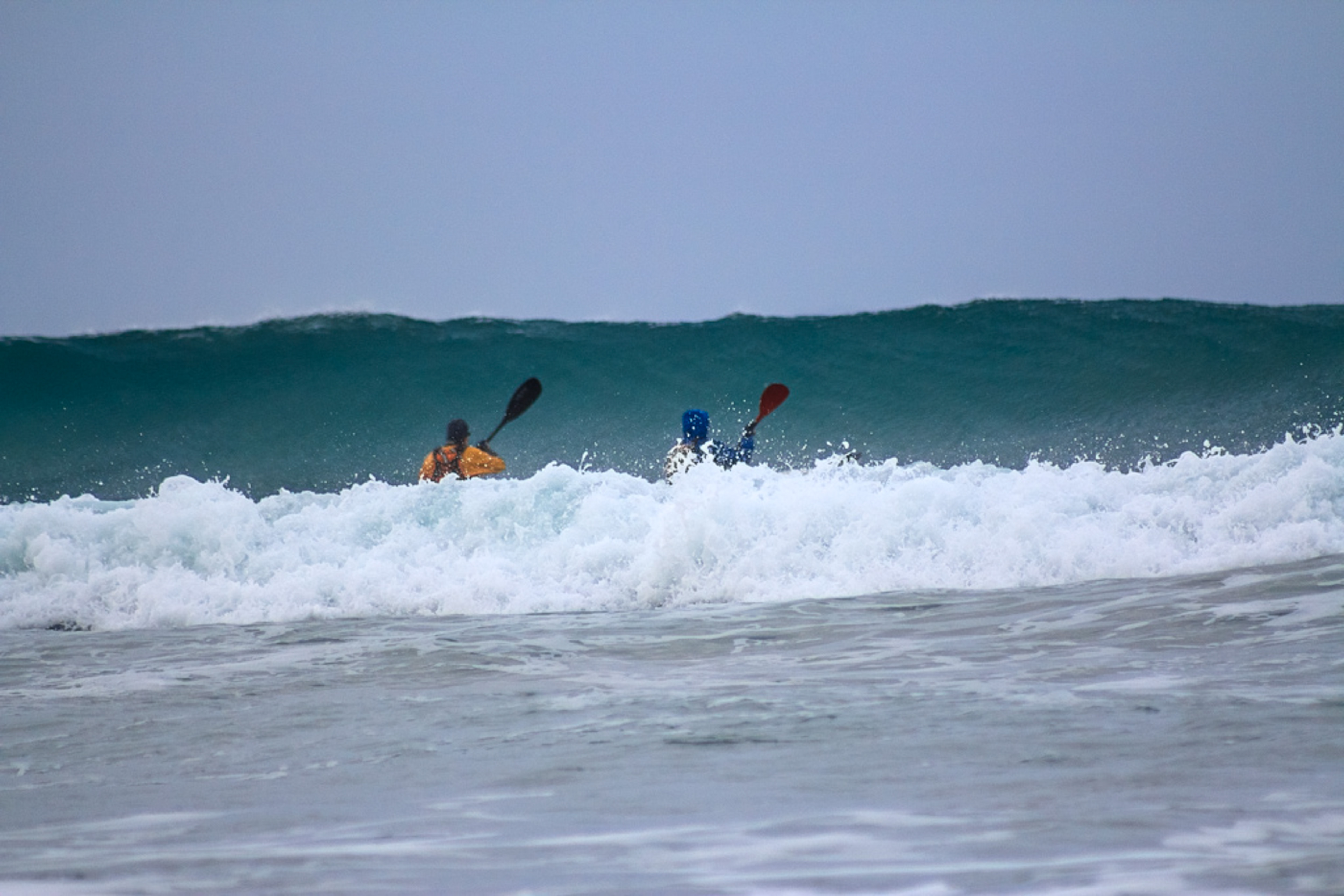
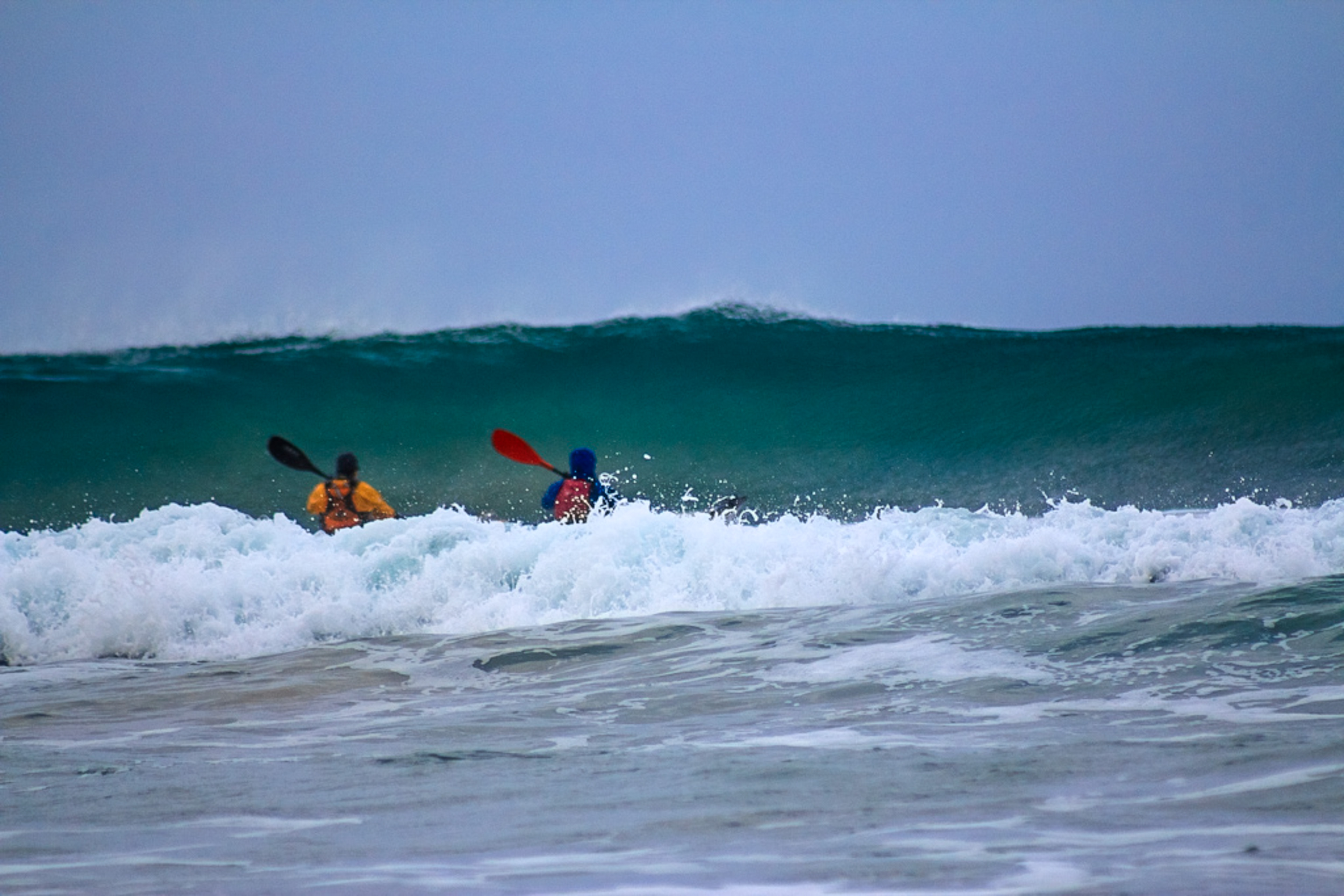
A few pic’s of Terry and me trying to get out past the breakers during a club day paddle at Waratah Bay (Gippsland Coast), in June. As the tide went out the waves got steeper. It was all a matter of timing. Sometimes we misjudged, as you can see by the images below. It was all good fun. Thanks to Bronwyn for the photography.
Heading out into the surf. Me at left. Terry on the right.
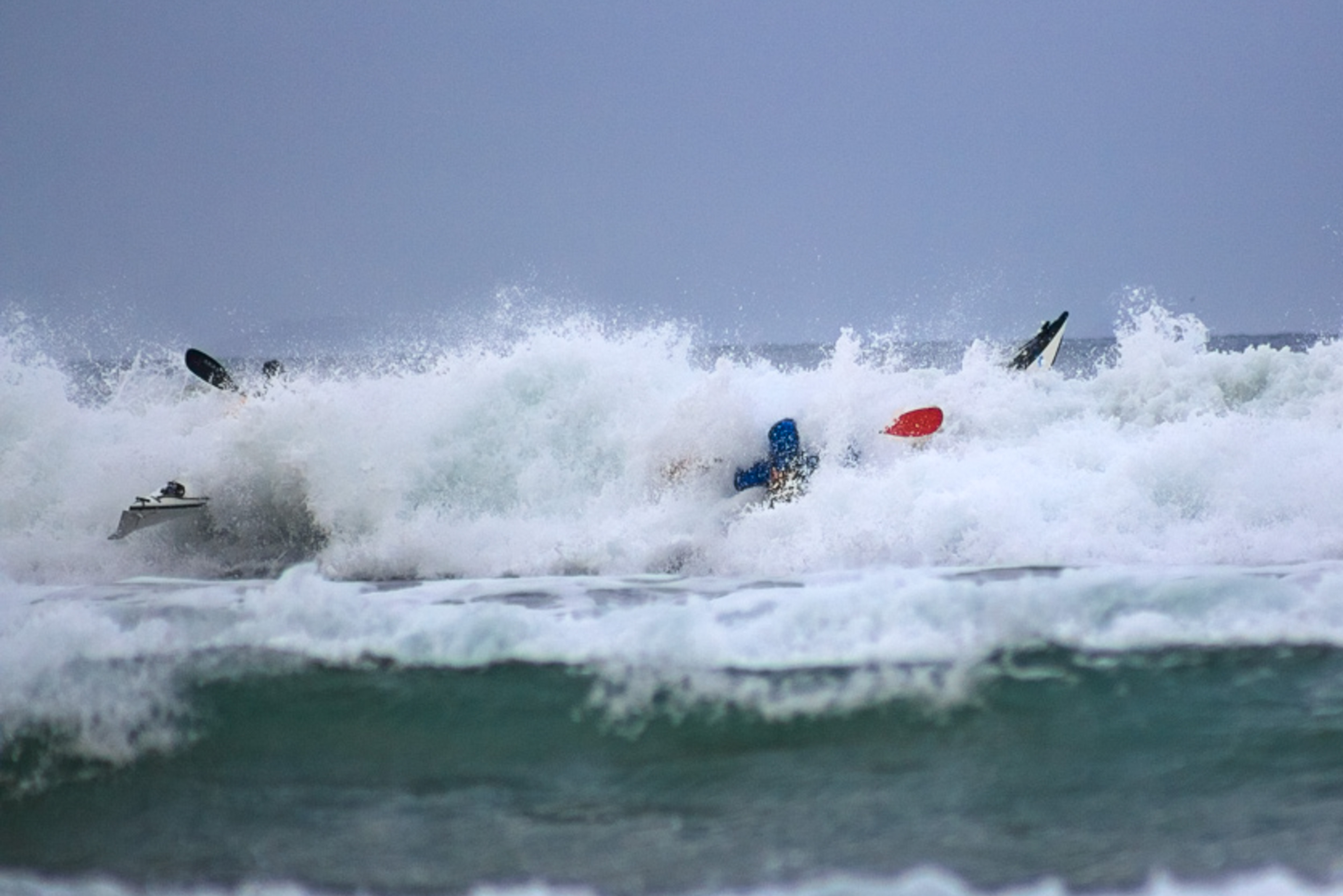
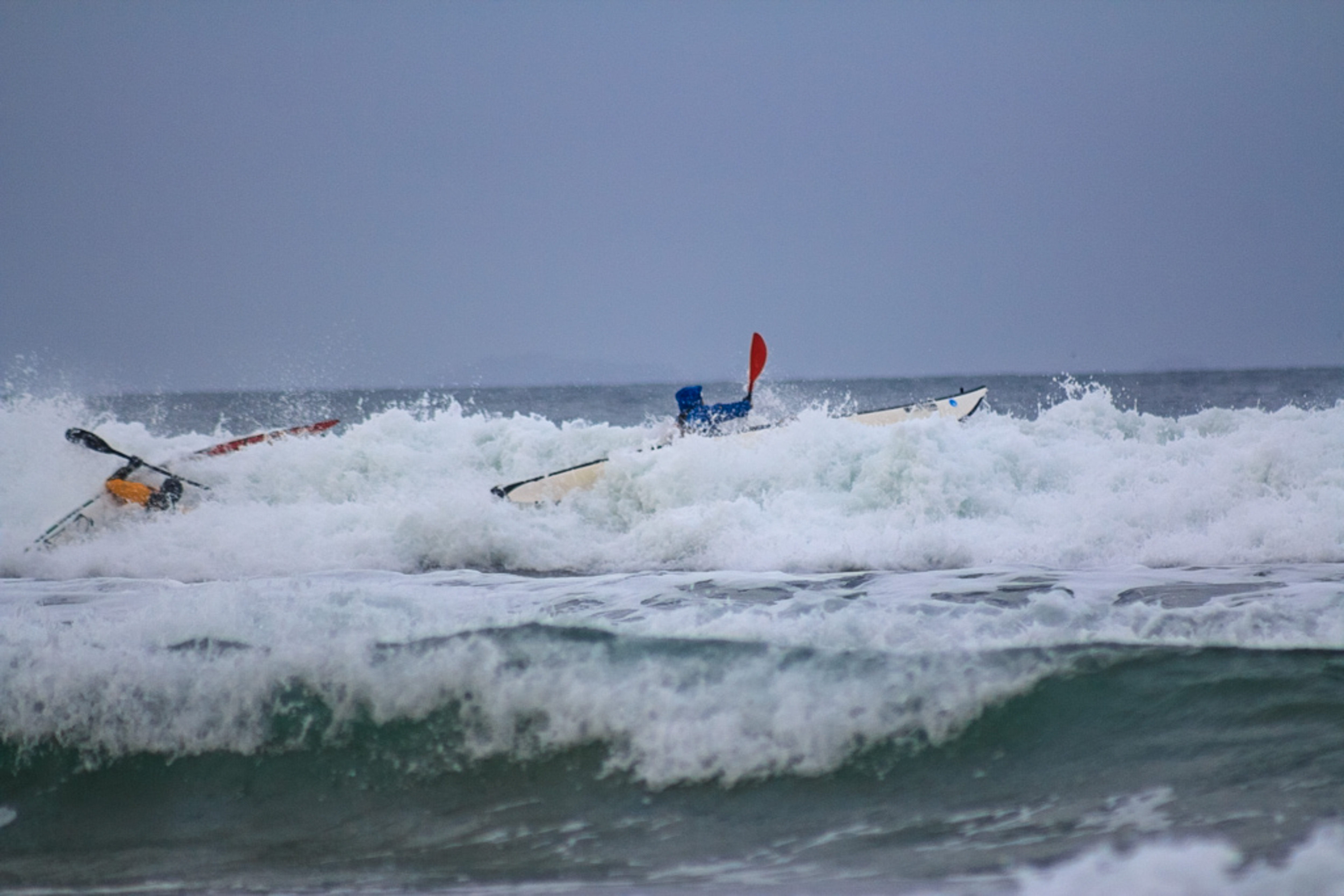
Oops! Paddle hard – we might make it.
Nope, too late. Take a breath.
Now its taking us backwards. No chance of steering out of this.
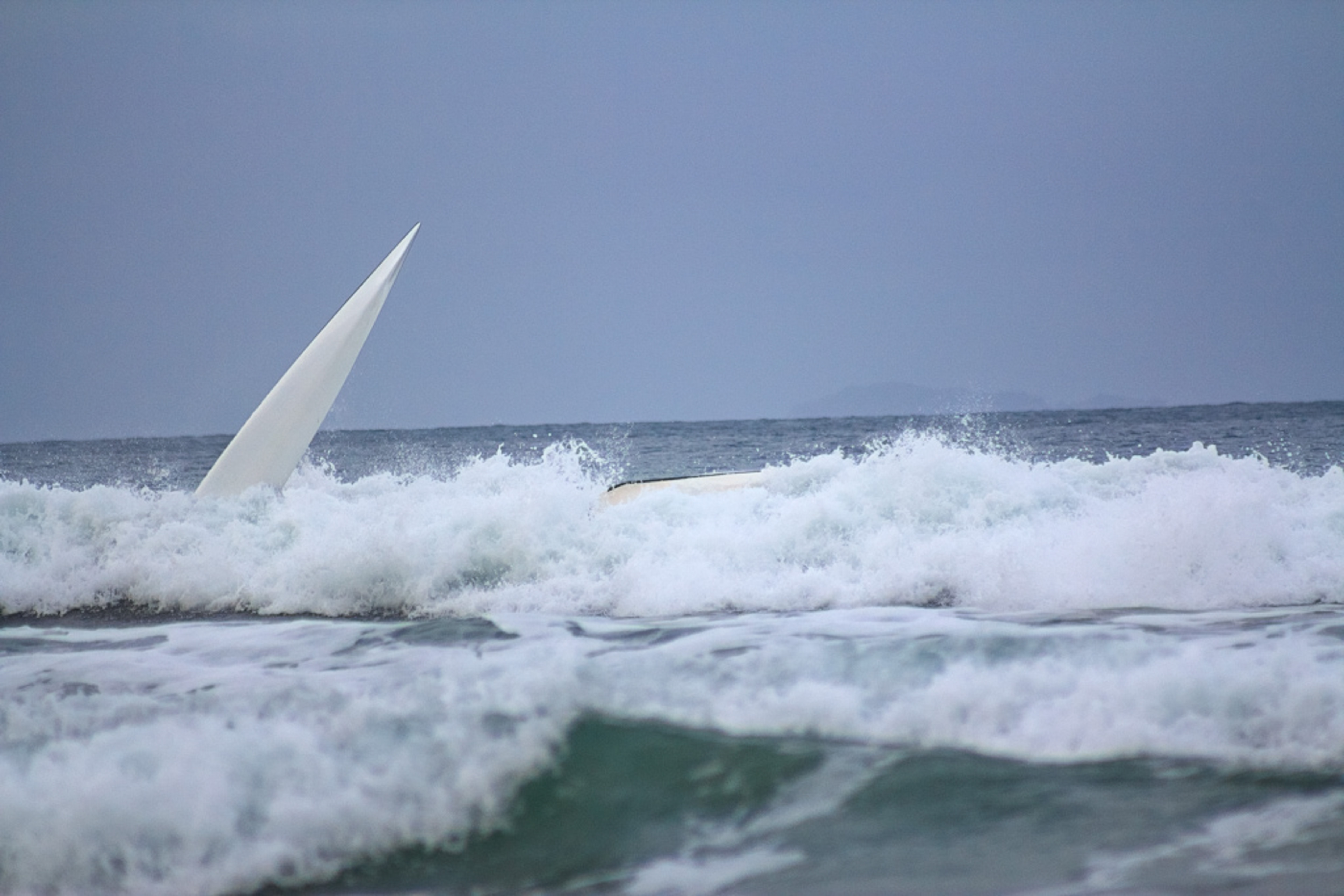
I’m going over.
Me pointing skywards. Terry eventually rolled back upright. I bailed out.
For more than 10 years I had been thinking of crossing Bass Strait from Victoria to Tasmania in a sea kayak – a distance of 330 kilometres. There was something fascinating and alluring about such a venture on the wild seas of the Strait, more so than any other place in Australia. I knew it would be challenging and demanding, with a number of long days (in excess of 10 hours) sitting in a small craft, traversing large stretches of open water. The whole trip could take up to three weeks, although the actual days of paddling are often less than half the total days away as weather conditions play a big part in determining when you can paddle, particularly on the longer distance runs.
You need to be self sufficient in terms of food and water and undertake extensive preparation and training. In addition to the physical requirements it was important to be mentally ready and in a state of mind to feel comfortable in rough ocean conditions. I felt I could do it.
In early 2013 I made the first step towards realising my dream by purchasing a second hand sea kayak. I then joined the Victoria Sea Kayak Club (VSKC) to gain experience and skills with an underlying purpose of undertaking this trip. There were many opportunities to participate in VSKC events and training days with friendly and helpful members offering advice and suggestions on everything from techniques to choice of equipment and gear.
Preservation Island.
There were islands with safe landing sandy beaches located strategically across the Straits eastern side to enable a paddle from one place to another in a single day (there were two occasions when we left in the dark before sunrise). The longest distance is between Killiecrankie and Erith Island, at approx. 70 km. There are settlements on the larger islands (Cape Barren and Flinders) but many of the smaller islands are uninhabited (apart from penguins and rats).
Map showing route paddled from Little Musselroe Bay, Tasmania to Port Welshpool, Victoria. Distance of 330 kilometres. Took us 18 days. Stuck on Erith Island for six days. The biggest day was from Killiecrankie to Erith Island – 10 hours and 70 klms.
My kayak is an Australian made kevlar Mirage 580. I chose the Mirage 580 (at 5.8m long) mainly because of my height (191 cm). Most sea kayaks are between 5.3 to 5.5 metres in length. I was able to find a second hand Mirage 580 in Melbourne for a reasonable price in very good condition with accessories including an electric bilge pump and compass. Oddly enough the previous owner sold it after an unsuccessful Bass Strait crossing attempt in 2012 (his group wasn’t prepared for cyclic weather changes and got stranded on Hogan Island with insufficient water and supplies)!
After a couple of years of routine kayak training in a variety of different waters and conditions including Port Phillip and Westernport Bay, Phillip Island and Wilsons Prom, I was confident that I had acquired sufficient skills to be able to successfully cross Bass Strait as a member of a group.
An opportunity came about when Julian a VSKC member who had previously done the crossing a number of times, posted a Bass Strait crossing trip on the VSKC’s event calendar. The trip was originally planned as a VSKC trip from Vic to Tassy, then Julian was going to help lead an army ‘Mates4mates’ group back to Victoria. However the Vic to Tassy component was dropped and Wim, Bill and me, as a semi-independent group, would start with the Mates at Tassy.
The Mates4Mates are a military group made up of the injured, ill and wounded former and serving Australian soldiers. Some Mates have PTSD (post-traumatic stress disorder). As part of their program they have available different challenges for post-combat rehabilitation and to push them physically and psychologically. The Bass Strait challenge was one of the activities on their program.
Preservation Island after crossing Banks Strait from Little Musselroe Bay.
Many of the Mates had minimal kayaking experience and were introduced to the activity only months before the trip. There were nine kayaks (six singles and three doubles) in the Mates group. We stayed with the Mates4mates for the first week between Little Musselroe Bay and Killiecrankie until leaving them at Killiecrankie when a strong wind forecast caused the Mates to remain on land in accordance with their paddling rules.
During the two and a half weeks of our trip (from March 15 to Apr 1) we encountered three other kayaking groups (apart from Mates4mates) – three from NSW (all brothers), four paddlers from WA and Jake and Tyler from Victoria (whom we spent four days with on Erith Island). There was another group of two that evidently by-passed us travelling in the opposite direction at Erith/ Deal Island (they stayed at Winter Cove on Deal whilst we were at Erith Island).
DAY 1 (Sun 15 Mar 2015) – Little Musselroe Bay to Preservation Island.
It was to be an eventful first day on the water. There were 12 kayaks (nine Mates4mates and us three Victorians) all lined up on Little Musselroe river beach. At 9.00am we departed for our journey across Bass Strait. First of all we had to cross the notorious Banks Strait – a sub strait of the Bass Strait. We had a 20knot SE wind which was favourable weather for our 03 ° north magnetic bearing crossing.
It was an interesting first days paddle. To start with one of the Mates got grounded on the rocks when negotiating the Bays entrance on the ebbing tide.
Day 1 – About to depart Little Musselroe River Beach. Is there anything we have forgotten?
Setting up camp on Preservation Island. Phone reception just up the hill.
When only 10 minutes from the beach I made an embarrassing mistake when I lost a paddle. My sail was up to take advantage of the following wind. My paddle leash was a plastic coil type and at times it annoyingly ties itself in a knot so I left it off. The sea was quite choppy. When I was fitting my Gopro camera to my head with the use of a head strap I placed the paddle across the deck to free up both hands. As I went to grab my paddle it wasn’t there! By the time I got organised and dropped my sail, grabbed my spare paddle from the rear deck and did a 180° turn I couldn’t find my paddle. It was gone. From then on I kept my paddle leashed.
By afternoon the seas were increasing to about 2 metres with whitecaps and the occasional breaking crests. This was a real test for some of the Mates who were fairly new to paddling and it wasn’t long before a double kayak capsized. Both paddlers ended up in the water after an unsuccessful brace following a breaking wave. We assisted them to get back in and stabilise their boat until all the water was pumped out and everything squared off. After the second capsize that afternoon (by the same crew) we emptied the numerous water bags that were secured above the deck to lower their centre of gravity. The electric bilge pump ceased to work after their first capsize so they were forced to use their hand pump. This was tiring work for already fatigued paddlers. I reckon they would have slept well that night. Banks Strait lived up to its reputation as an unpredictable stretch of water.
We arrived at Preservation Island at 4.00pm after covering some 40 km. Preservation Island was named following the wreck of the merchant ship Sydney Cove in 1797. During the early-to-mid-19th century the island was a base for sealers exploiting fur seals and southern elephant seals. This might explain why we didn’t see any seals on the island?
DAY 2 (Mon 16 Mar) – Preservation Island to Trousers Point
We left Preservation Island at approx. 11.00am and paddled to Cape Barren Island and its only settlement, called The Corner, for a pie and ice cream. The residents of Cape Barren Island consist of an Aboriginal community of approximately 70 people. Most of the residents are descended from a community of mixed descent (European and Aboriginal people) who had originally settled on several smaller nearby islands but relocated to Cape Barren Island in the late 1870s. Australia’s only native goose, the Cape Barren Goose, was first sighted on this island.
A popular spot – 19 kayaks on Trousers Point beach.
We then crossed over to Flinders Island arriving at Trousers Point, part of Strzelecki National Park, at 4:00pm. The wind was approx. 12 knots (kn). The sails assisted us for the final 10 km. After hauling the kayaks up on the narrow beach above high tide level we set up camp. Shortly afterwards three kayakers (all brothers) from NSW arrived closely followed by four paddlers from WA. Both of these groups were travelling in the opposite direction to us. They had been away nine days since leaving Port Welshpool. Trousers Point beach had 19 kayaks parked on it that day!
Trousers Point. Mt Strzelecki in background. Dick Smith’s motor launch. Dick had a apparently flown out that morning.
Basil, Bill, Wim and Matt at Trousers Point. No shortage of things to talk about.
DAY 3 (Tue 17 Mar) – Trousers Point
View from halfway up Mt Strzelecki.
There was a strong wind warning and the seas were quite choppy so we didn’t mind taking the day off and walking to the top of Mount Strzelecki at a height of 756m. It took us about 4 hours return to complete the walk which got our leg muscles working – more calories lost that day! We couldn’t see much from the summit as we were in the clouds but had good views on the way up. It reminded me of Wilsons Prom with the spectacular scenery of huge granite boulders and rock faces.
The Mates and us at the top of Mt Strzelecki. What happened to the sun?
DAY 4 (Wed 18 Mar) – Trouser Point to Whitemark
Whitemark, Flinders Island. Now for lunch at the pub.
We were looking forward to a meal at the Whitemark pub and a visit to the bakery. We covered the 17kmpaddle that morning without a hitch and landed on the beach at the public park. The wind was 15knots but the bay was fairly sheltered from nearby islands.
After setting up camp we used fresh water from the sink in the toilets to wash the salt off ourselves. We then got dressed into dry clothes for lunch at the pub. It was chicken parma for everyone. The meal was one of the most generously sized meals I have ever had and was very tasty. Most of us went back to the pub that evening for dinner after a relaxing cuppa at the cafe. I thought that if I keep up this routine I won’t lose any weight at all on this trip.
DAY 5 (Thu 19 Mar) – Whitemark to Roydon Island
At Whitemark getting ready to launch.
The biggest day so far – 46 km. We set off at 7.30am and didn’t get to our destination until 6.00pm. We had a break for early lunch near Long Point whilst waiting for the 20knot NW wind to abate. After rounding Long Point at midday we stopped at Emita for a 30 min break and then proceeded for Roydon Island against a 12 knot headwind for what seemed like ages. There was a pleasant relief when we got a favourable breeze for the last hour after turning west and running for Roydon Island. The sails went up to make the most of the conditions.
Stopped for lunch near Long Point, Flinders Island. I had enough food for 28 days.
Made it to Roydon Island.
Looking towards Flinders Island from Roydon Island
Roydon Island was an idyllic location. The landscape was picture perfect. The penguins were very noisy, calling to each other that evening, as they wandered through our camp site to their burrows. The same chorus was heard early the next morning.
DAY 6 (Fri 20 Mar) – Roydon Island
Rough conditions looking south from Roydon Island. A rest day.
From north of Roydon Island. Flinders Island in background.
Remained at Roydon Island for the day. No paddling given the 20 – 25knot wind from the west. Sunny, mostly at 21°C. There was good drinking water in the tank at the hut. We did some exploring of the Island.
DAY 7 (Sat 21 Mar) – Roydon Island to Killiecrankie
Craggy Rocks (20km) from Killiecrankie beach. Deal Island is beyond.
Departed at 11.15am at high tide for Killiecrankie. It was a bit choppy around the headland and we kept clear of the rocks. The wind was about 10 knots from the west so once we passed the headland and turned east we put up our sails to assist. We arrived at Killiecrankie at 2.00pm, unpacked our boats and proceeded to The Deep Bite Cafe for arvo tea and back again for a meal that evening. Seeing Deal Island on the horizon beckoned us.
DAY 8 (Sun 22 Mar) – Killiecrankie
No paddling – too windy. The Mates arranged a rental house at a nearby town. We were invited so we all went to Palana by vehicle. The Mates looked after us again. The kayaks were left high up on the beach at Killiecrankie.
DAY 9 (Mon 23 Mar) – Killiecrankie
We shifted back to Killiecrankie beach with intentions of paddling on Tuesday. Occasional showers in the afternoon.
Mt Killiecrankie from Deep Bite Cafe – taken whilst enjoying a cappuccino.
DAY 10 (Tue 24 Mar) – Killiecrankie to Erith Island
Bill, Wim and I got up at 5.00am to hit the water at 6.00am. We ended up leaving the Mates4mates at Killiekrankie when we went by ourselves to Erith Island. The Mates were restricted on paddling on high wind warning days, whereas Bill, Wim and I were happy to take advantage of the forecast 20 knot following wind that day. We were three individuals who had made a decision to paddle together from here on. (The Mates didn’t get an opportunity to leave Killiecrankie for another week!)
Low tide was at 9.30am and with a bearing of 301 ° north magnetic and a 2kn tide we left the beach in the dark and paddled into Bass Strait. It became quite rough a few kilometres from the shore and by then, with a 25kn wind behind us, we were fully committed. The next stop was Deal or Erith Island.
As the hours went by we passed Craggy Island (20kmfrom Killiecrankie) and Wright Rock (40kmfrom Killiecrankie). About 20km from Deal Island we decided to make for Erith Island as it was closer for our next leg to Hogan Island and we had sufficient daylight. We arrived at Erith Island at 4.00pm. 10 hrs and 70 kms.
Normally we would cover this distance given the tail wind in much quicker time than 10 hours, however, the 25knot wind and rough conditions caused us to do a fair amount of bracing in between paddling and it was too rough to raise the sails. Bill attempted to sail but broke his mast after broad siding near Craggy Island that morning so I was the only one with a sail (Wim didn’t have a sail fitted) which assisted me during the last 20km when winds dropped below 20kn.
Weather on Tues 24 Mar. Up to 25kn in morning when paddling from Killecrankie to Erith Island. Note high wind forecast on Thur/Fri.
The seas in the morning were rougher than forecast. This was confirmed by the updated forecast which increased the wind from 20kn to nearly 25kn. Had the forecast been updated before we left we may not have launched that day. This was the roughest day of our trip and it required constant focus and concentration. Fortunately we had the skills to be able to safely handle these conditions. It was not as a s bad as one of our training days. In the afternoon I was actually enjoying surfing down the face of the 2-3m waves.
Erith Island hut. Our home for six days.
All the same I was glad to hit the beach at Erith Island. My bum was sore and I was looking forward to standing up after 10 hours in the confines of a kayak. We decided to stay in the Erith hut. Built in 1958 and maintained by Friends of Erith it was quite comfortable with a glass front wood heater and good drinking water. Just as well as high winds were approaching. I battled through the scrub that evening to get to the West of the Island for phone reception not realising that there was a cleared track taking off at a point from the beach which I didn’t discover until the next day!
DAY 11 (Wed 25 Mar) – Erith Island
At 10.00am we did the 2km paddle across the Murray Strait to Deal Island and met the caretakers, Tim and Lyn , and two yachties, Ian and Snowy who had their Yacht anchored at East Cove. Evidently Ian and Snowy had sailed their yacht from Flinders the same day as we had paddled from Killie. They too had a wild ride. Next we walked to the lighthouse and scaled the stairs to look at the commanding 360 °view. The lighthouse was de-activated in 1992 and replaced by beacons on two rock islands nearby. The museum was well worth a look. There were lots of Bennett’s wallabies and Cape Barren Geese on the Island. At 3pm we paddled back to Erith Island and met two paddlers who had just arrived from Hogan Island in a plastic double kayak. Jake and Tyler were tackling the bass Strait but in a different direction. It was good to have their company for the next three days. Tyler caught a nice Short-finned Pike for dinner. The daily temp was 16°C.
Ian and Snowy’s yacht at East Cove, Deal Island. What an idyllic spot.
Snowy, Ian (yachties) and Lyn (caretaker) on Deal Island.
View from Deal Island lighthouse looking south to Flinders Island. Did we paddle all that way?
(L,R) Wim, Bill, Ian, Tyler, Snowy and Jake on Erith Island. Nice fish Tyler.
DAY 12 (Thu 26 Mar) – Erith Island
Too windy to paddle with 30 – 40kn wind from the west. We cleaned and sorted through our gear and tidied up. Ian had shifted his yacht across from Deal Island. Lit a campfire in the evening and got a visit by Ian and Snowy.
From Erith hut looking towards Murray Pass. It looks rough out there. No paddling today.
DAY 13 (Fri 27 Mar) – Erith Island
Still windy. Stronger gusts than yesterday with spray being whipped up on the bay. Murray Pass and the ocean looked really rough with a big swell and white water. Ian and Snowy offered to take us across to Deal Island in their yacht. Wim and I chose to stay back in the comfort of the hut. The other four got quite wet just getting shuffled from the beach to the yacht in the small inflatable tender. Ian visited us that evening and brought a large hot baking tray of roast potato and vegies which we gobbled up in no time.
DAY 14 (Sat 28 Mar) – Erith Island
The weather had settled somewhat so we decided to get some exercise and paddled with Jake and Tyler across to Deal Island so they could walk to the lighthouse before us three did a circumnavigation of Dover and Erith Island in a clockwise direction. As we hit the south west coast of Dover Island we hit a 15kn headwind and the residual swell from the day before . It was tough going for a while. Once we turned the corner I could spend more time relaxing and admiring the spectacular coastline and rugged cliffs of Erith Island. I wish I hadn’t left the Gopro behind as I would have loved to get a photo of this north side of the Island. Three hours and 17km later we arrived back at the Cove. This was a training day so no sailing. Before hitting the beach we boarded Ian’s yacht to have a much welcomed cuppa with him and Snowy, and say goodbye as they were leaving for NSW the next morning.
As we were disembarking from Ian’s yacht we observed a large catamaran entering the cove. It had sailed from Port Albert with a dozen walkers from the Melbourne Bushwalkers. They we going to spend the next three days camping at Erith Island and walking daily on Deal Island – being ferried daily by the catamaran. They were a friendly group and camped near the old stockyards.
Members of Melbourne Bushwalkers. Their food was fabulous.
The rats were getting bolder by the day and made themselves home at night scampering everywhere, including over us as we slept. All food had to be hung from hooks and well secured in the kayaks. To leave a muesli bar in your pfd pocket was asking for a rat to eat a hole in it – as Wim found out. The Friends of Erith had left a tub of poison so I gave the rats a daily feed. By the end of the stay the tub was empty but the rats were still very active so there must have been quite a few around.
The Swashway between Erith and Dover Islands. At high tide we made it through the Swashway enroute to Hogan Island.
DAY 15 (Sun 29 Mar) – Erith Island
Hogan Island on the horizon (from Erith).
For Wim, Bill and I it was rest day whilst Jake and Tyler had departed early that morning for Killiecrankie. They had a good west wind. That evening we were invited by the bush walkers for dinner at their camp. Lots of food was prepared which was a good change from dehydrated and freeze dried packet food. They made us very welcome and really looked after us. We said we were going to Hogan Island the next morning. I think they took pity on us paddling all the way back to Victoria in our lightweight narrow boats but wished us well. We met some of them on the beach at dusk that evening to watch the penguins come ashore. This was our sixth night on Erith Island.
DAY 16 (Mon 30 Mar) – Erith Island to Hogan Island
Hogan Island – land of the rats.
This was the day to get to Hogan Island. The weather was not great with a headwind and ebbing tide against us but we were keen to make a move as we had been on Erith for six days and the forecast showed a small window the following day when we should be able to get to the Prom (and Victoria). There was no fresh water on Hogan so we didn’t want to get stuck there. We took about 14 litres of water each.
The Kayaks were packed and in the water at 7.20am in time for high tide. We were able to knock a couple of kilometres off the trip that day by using the Swashway between Erith and Dover Islands. The Swashway is so shallow that it can only be paddled about 30 min either side of high tide. Even then you have to carefully choose your path. See video.
Hogan Island.
Top of Hogan Island. Normally I would have walked to the top for some views and photos but I thought it best to save my energy for another big day on the water.
We battled 12-14kn winds in our face for 42km that day arriving at Hogan Island at 3.50pm. This was the most grueling and demanding day of the trip for me – 8.5hrs to cover 42kms (less than 5km per hour ave. speed). It was constant hard paddling with no stops. To stop would mean being beaten backwards by the wind and tide so we ate (and did everything else) on the move.
We had heard that there were rats on Hogan Island but we didn’t think they were so brazen. No sooner had we landed that we observed a large rat heading towards our boats on the beach. I investigated to find it in my kayak cockpit up on its back legs gnawing into my under deck bag. It wasn’t too worried when it saw me and I had to bang the boat to get it out. I then removed all traces of food. To stop the rats from eating holes through our tent walls we left a free feed of oats close by that night.
DAY 17 (Tue 31 Mar) – Hogan Island to Johny Souey Cove
The day was looking good. We set off at 8.45am. 20 minutes later we had paddled around the islands north side and steered a magnetic bearing of 276° towards Wilsons Prom. There was virtually no wind. It was a glorious day. I don’t think we had paddled in such perfect weather conditions yet. A superb day to cover the 52km to Refuge Cove. As the hours melted away the mountains on the Prom were gradually getting larger. Half way across we noticed a ship on the horizon. 20 min later at a few km away it seemed to be bearing down on us and we were thinking about evasive action or getting on channel 16 and contacting the ship. But as the minutes passed we could see that it was going to cross our path less than 500 metres ahead. It was a large container ship probably doing 30kn. You have to be alert in the shipping channel.
Johny Souey Cove, Wilsons Promontory National Park, Victoria. It was a great feeling to be in Victoria.
The going was good so at midday we decided to change course to Johny Souey Cove. This would enable us to easily catch the flooding tide to Port Welshpool the following morning before high tide at 10.30am. We pointed towards Rabbit Island on the horizon and started thinking about the pleasures of getting out of the kayak and stepping foot in Victoria. We arrived at 6.15pm and congratulated each other on the achievement. This was our second longest day on the water. Paddled 9.5hrs and covered 60kms that day (6.3km/hr).
DAY 18 (Wed 1 Apr) – Johny Souey Cove to Port Welshpool
Not wanting to miss the advantage of the flooding tide we set of at 6.40am with torches. Absolutely no wind and calm conditions. The tide was taking us along at an ave. 9km/hr. The closer we got to Port Welshpool the more fishing boats we saw and heard. The high water allowed us to cut across the shallow end of Little Snake Island. Three hours later at 9.40am we arrived at Port Welshpool. Hooray, we made it. We all danced on the beach. I was soon giving my wife Margie a hug. Bill kindly shouted us a beer at the pub to celebrate the victorious crossing.
Completion of our trip. Wim, Bill and me at Part Welshpool.
On reflection I was physically in shape for the big days, had the energy and felt confident in handling the conditions. The physical complaints were minor such as a few blisters on my fingers and a sore bum from many hours in the seat. Some moments were personally testing and I was out of my comfort zone, however these experiences are definitely positive and character building. On a few occasions I was reckless and made a mental note to do things better next time. I only lost one kilo in body weight during the expedition but I suppose I was quite lean from all the training before leaving.
During the trip I learnt heaps. Expedition kayaking is quite a bit different to a day paddle in the bay or on a river. It’s important to make yourself familiar in the full use of all necessary electronic equipment such as GPS, (PLB) Personal Locator Beacon/ EPIRB, Spot tracker, UHF radio etc and take sufficient solar panel charger or power bank external batteries with USB and phone cables for charging your smart phone. Monitoring daily weather uses up battery life. Use only Telstra service phones – service is available within a reasonable walking distance of all camping sites.
Having a sail certainly assisted. In a tail wind, or up to 45° into the wind, its advantageous to use the sail to augment paddling. Its better if all kayaks in the pod have sails fitted. In certain conditions paddlers without sails can’t maintain the speed of the other paddlers who are using sails. Having a sail means less time on the water and less calories burnt.
Wearing a high vis hat and colourful layers helped retain visual contact between paddlers, particularly in rough weather. It’s surprising how hard it is at times to keep track of a fellow paddler in rough seas. The sail is also an excellent means of making a kayak more visible.
In retrospect I think it was better that we split from the Mates4mates after the first week. Not that they weren’t a nice bunch of guys – quite the opposite, they were great company and fun to be around. It was more a case that so many paddlers in a group made it unwieldy, and the paddling structure that was implemented made me feel restricted. We found that once we separated as a smaller group we could practice navigating and making strategic decisions which we weren’t able to do as part of the larger group. Also I felt that being a member of a smaller group of three, that successfully completed the crossing, gave me a bigger sense of overall achievement.
As it turned out the Mates4mates arrived at Port Welshpool four days after us. After reaching Deal Island they didn’t have to wait long to make their run to Victoria.
This was a fantastic trip that will stay with me forever. It was a dream realised, full of adventure and excitement. Meeting all sorts of people on the way made it more interesting and memorable. Thanks to Wim and Bill for the good times and friendship, to the Mates4Mates for their assistance and company and to Julian from the VSKC for the opportunity.
A video of a weekend kayak trip to the Seal Island Group off Wilsons Promontory. Our destination was Cliffy Island, one of the four islands in the group. George and I watched Julian as he managed to pull his boat up out of the water onto the rocky shore. This was a training trip for our planned crossing of the Bass Strait in March 2015.